Note:
The expiration time in the watch graphic is amended if the watch is
replaced, cancelled or extended.
Note:
Note:
The expiration time in the watch graphic is amended if the watch is
replaced, cancelled or extended.
Note: Click for
Watch Status Reports.
SEL0
URGENT - IMMEDIATE BROADCAST REQUESTED
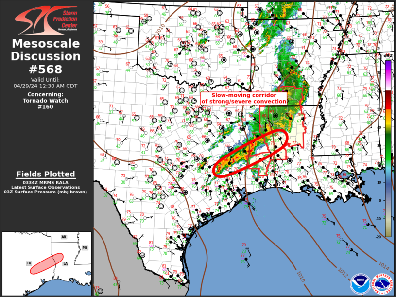
Tornado Watch Number 160
NWS Storm Prediction Center Norman OK
640 PM CDT Sun Apr 28 2024
The NWS Storm Prediction Center has issued a
* Tornado Watch for portions of
Southern Arkansas
Western and Northern Louisiana
Southeast Texas
* Effective this Sunday night and Monday morning from 640 PM
until 200 AM CDT.
* Primary threats include...
A couple tornadoes possible
Scattered damaging winds likely with isolated significant gusts
to 75 mph possible
Scattered large hail events to 1.5 inches in diameter possible
SUMMARY...Organized band of storms including supercells and line
segments will move east across the Watch area this evening into the
overnight. The risk for tornadoes, severe gusts, and large hail
will be the hazards with the stronger storms.
The tornado watch area is approximately along and 65 statute miles
east and west of a line from 25 miles north of El Dorado AR to 30
miles southwest of Fort Polk LA. For a complete depiction of the
watch see the associated watch outline update (WOUS64 KWNS WOU0).
PRECAUTIONARY/PREPAREDNESS ACTIONS...
REMEMBER...A Tornado Watch means conditions are favorable for
tornadoes and severe thunderstorms in and close to the watch
area. Persons in these areas should be on the lookout for
threatening weather conditions and listen for later statements
and possible warnings.
&&
OTHER WATCH INFORMATION...CONTINUE...WW 158...WW 159...
AVIATION...Tornadoes and a few severe thunderstorms with hail
surface and aloft to 1.5 inches. Extreme turbulence and surface wind
gusts to 65 knots. A few cumulonimbi with maximum tops to 500. Mean
storm motion vector 24035.
...Smith

   SEL0

   URGENT - IMMEDIATE BROADCAST REQUESTED
   Tornado Watch Number 160
   NWS Storm Prediction Center Norman OK
   640 PM CDT Sun Apr 28 2024

   The NWS Storm Prediction Center has issued a

   * Tornado Watch for portions of
     Southern Arkansas
     Western and Northern Louisiana
     Southeast Texas

   * Effective this Sunday night and Monday morning from 640 PM
     until 200 AM CDT.

   * Primary threats include...
     A couple tornadoes possible
     Scattered damaging winds likely with isolated significant gusts
       to 75 mph possible
     Scattered large hail events to 1.5 inches in diameter possible

   SUMMARY...Organized band of storms including supercells and line
   segments will move east across the Watch area this evening into the
   overnight.  The risk for tornadoes, severe gusts, and large hail
   will be the hazards with the stronger storms.

   The tornado watch area is approximately along and 65 statute miles
   east and west of a line from 25 miles north of El Dorado AR to 30
   miles southwest of Fort Polk LA. For a complete depiction of the
   watch see the associated watch outline update (WOUS64 KWNS WOU0).

   PRECAUTIONARY/PREPAREDNESS ACTIONS...

   REMEMBER...A Tornado Watch means conditions are favorable for
   tornadoes and severe thunderstorms in and close to the watch
   area. Persons in these areas should be on the lookout for
   threatening weather conditions and listen for later statements
   and possible warnings.

   &&

   OTHER WATCH INFORMATION...CONTINUE...WW 158...WW 159...

   AVIATION...Tornadoes and a few severe thunderstorms with hail
   surface and aloft to 1.5 inches. Extreme turbulence and surface wind
   gusts to 65 knots. A few cumulonimbi with maximum tops to 500. Mean
   storm motion vector 24035.

   ...Smith
 Note:
The Aviation Watch (SAW) product is an approximation to the watch area.
The actual watch is depicted by the shaded areas.
Note:
The Aviation Watch (SAW) product is an approximation to the watch area.
The actual watch is depicted by the shaded areas.
   SAW0
   WW 160 TORNADO AR LA TX 282340Z - 290700Z
   AXIS..65 STATUTE MILES EAST AND WEST OF LINE..
   25N ELD/EL DORADO AR/ - 30SW POE/FORT POLK LA/
   ..AVIATION COORDS.. 55NM E/W /20NNW ELD - 42NNW LCH/
   HAIL SURFACE AND ALOFT..1.5 INCHES. WIND GUSTS..65 KNOTS.
   MAX TOPS TO 500. MEAN STORM MOTION VECTOR 24035.

   LAT...LON 33589169 30749244 30749463 33589395

   THIS IS AN APPROXIMATION TO THE WATCH AREA.  FOR A
   COMPLETE DEPICTION OF THE WATCH SEE WOUS64 KWNS
   FOR WOU0.
Watch 160 Status Report Message has not been issued yet.
Note:
Click for Complete Product Text.
Tornadoes
Probability of 2 or more tornadoes
|
Mod (40%)
|
Probability of 1 or more strong (EF2-EF5) tornadoes
|
Low (20%)
|
Wind
Probability of 10 or more severe wind events
|
High (70%)
|
Probability of 1 or more wind events > 65 knots
|
Mod (40%)
|
Hail
Probability of 10 or more severe hail events
|
Mod (40%)
|
Probability of 1 or more hailstones > 2 inches
|
Low (20%)
|
Combined Severe Hail/Wind
Probability of 6 or more combined severe hail/wind events
|
High (90%)
|
For each watch, probabilities for particular events inside the watch
(listed above in each table) are determined by the issuing forecaster.
The "Low" category contains probability values ranging from less than 2%
to 20% (EF2-EF5 tornadoes), less than 5% to 20% (all other probabilities),
"Moderate" from 30% to 60%, and "High" from 70% to greater than 95%.
High values are bolded and lighter in color to provide awareness of
an increased threat for a particular event.


 @NWSSPC