|
| Mesoscale Discussion 511 |
|
< Previous MD Next MD >
|
|
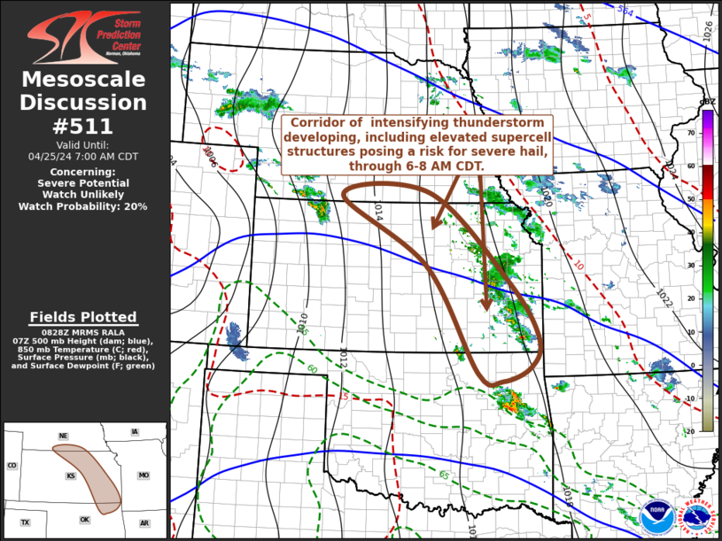
   Mesoscale Discussion 0511
   NWS Storm Prediction Center Norman OK
   0329 AM CDT Thu Apr 25 2024

   Areas affected...parts of south central Nebraska through eastern
   Kansas and adjacent northeastern Oklahoma

   Concerning...Severe potential...Watch unlikely

   Valid 250829Z - 251200Z

   Probability of Watch Issuance...20 percent

   SUMMARY...Developing thunderstorm activity may occasionally
   intensify with at least some increase in potential to produce severe
   hail through 6-8 AM CDT.  While it still appears unlikely that this
   will require a severe weather watch, trends will be monitored for
   this possibility.

   DISCUSSION...Scattered thunderstorm development is well underway in
   response to lift and destabilization associated with elevated
   moisture return  within bands of strengthening
   lower/mid-tropospheric warm advection across the central Great
   Plains.  This is initially focused in corridors across parts of
   western Nebraska into northwestern Kansas, and across eastern Kansas
   into northeastern Oklahoma, where initial moistening and
   destabilization has been weak.  However, more substantive moistening
   within the 850-700 mb layer is ongoing across much of western and
   central Kansas through eastern Oklahoma, beneath increasingly warm
   elevated mixed-layer air advecting east of the southern Rockies.

   Into the 11-13Z time frame, the latest Rapid Refresh suggests that
   the better low-level moistening may begin to increasingly underrun
   the sharpening eastern periphery of the stronger mid-level
   inhibition in a corridor roughly from Kearney/Hastings NE through
   the Emporia and Chanute KS vicinities.  Based on forecast soundings,
   it appears that this may lead to most unstable CAPE increasing in
   excess of 1000 J/kg, in the presence of sufficient cloud-bearing
   layer shear (beneath 30-50 kt westerly flow in the 500-300 mb layer)
   for persistent supercell structures capable of producing severe
   hail.

   ..Kerr/Thompson.. 04/25/2024

   ...Please see www.spc.noaa.gov for graphic product...

   ATTN...WFO...SGF...TSA...OAX...TOP...ICT...GID...

   LAT...LON   40209749 38379542 37259470 36689491 36409563 36569624
               38729754 40149974 40209749
|
|
Top/All Mesoscale Discussions/Forecast Products/Home
|
|


 @NWSSPC