|
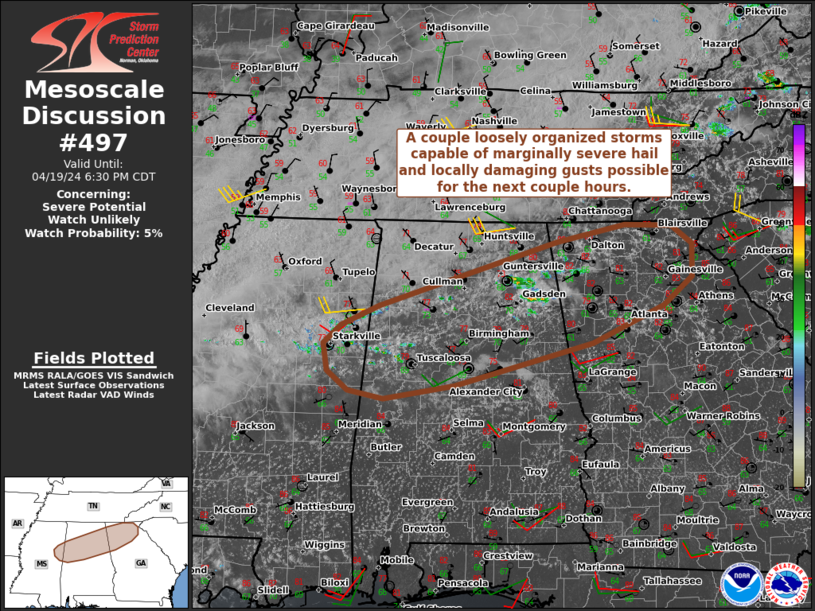
| Mesoscale Discussion 497 |
|
Next MD >
|
|
   Mesoscale Discussion 0497
   NWS Storm Prediction Center Norman OK
   0454 PM CDT Fri Apr 19 2024

   Areas affected...Portions of far east-central MS...northern/central
   AL...and northern GA

   Concerning...Severe potential...Watch unlikely

   Valid 192154Z - 192330Z

   Probability of Watch Issuance...5 percent

   SUMMARY...A couple loosely organized storms capable of marginally
   severe hail and locally damaging gusts are possible for the next
   couple hours. Watch not expected.

   DISCUSSION...Isolated thunderstorms are developing across portions
   of northern AL this afternoon, ahead of an outflow-augmented cold
   front draped across the region. Attempts at convective initiation
   are also evident over far east-central MS and northern GA.
   Antecedent heating/destabilization of a moist boundary layer (upper
   60s/lower 70s dewpoints) has yielded moderate surface-based
   instability ahead of the front. This may support a couple loosely
   organized multicells and transient supercell structures, given 30-35
   kt of effective shear -- characterized by a mostly straight
   hodograph (with weak low-level shear). Therefore, marginally severe
   hail (near 1 inch in diameter) and locally damaging gusts cannot be
   ruled out with any robust/sustained cores during the next couple
   hours, before the onset of nocturnal cooling/stabilization. Weak
   synoptic and mesoscale ascent should keep the severe risk localized,
   and a watch is not expected.

   ..Weinman/Guyer.. 04/19/2024

   ...Please see www.spc.noaa.gov for graphic product...

   ATTN...WFO...GSP...FFC...BMX...HUN...MEG...JAN...

   LAT...LON   33938810 34738544 34948442 34928373 34698342 34288342
               33948386 33478492 32958697 32778803 32878856 33118886
               33458893 33698866 33938810
|
|
Top/All Mesoscale Discussions/Forecast Products/Home
|
|


 @NWSSPC