|
| Mesoscale Discussion 161 |
|
< Previous MD Next MD >
|
|
Mesoscale Discussion 0161
NWS Storm Prediction Center Norman OK
1012 AM CST Tue Feb 27 2024
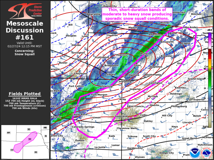
Areas affected...Eastern CO to northern NE
Concerning...Snow Squall
Valid 271612Z - 271915Z
SUMMARY...A short-duration moderate to heavy snow band that is
effectively producing sporadic snow squall conditions should spread
east-southeast into early afternoon across parts of eastern Colorado
and northern Nebraska.
DISCUSSION...700-mb frontogenetical forcing for ascent has supported
a narrow band of moderate to heavy snow across a portion of the
Denver Metro Area northeastward into north-central NE, per surface
observations and road cameras. The northeast extent of this band is
well removed from the surface cold front that is marching
south-southeast from IA to north KS and east-central CO. Strong,
post-frontal gradient winds are combining with the narrow snow band
to produce snow squall-like conditions with substantial reduction in
visibility despite the mesoanalysis snow squall parameter holding
less than 0.1. The stronger 700-mb frontogenesis is largely expected
to shift east in NE and gradually weaken while shifting southeast in
eastern CO. This may yield breaks in the ongoing thin band, a
scenario supported by recent RRFS guidance.
..Grams.. 02/27/2024
...Please see www.spc.noaa.gov for graphic product...
ATTN...WFO...FSD...OAX...GID...LBF...GLD...PUB...BOU...
LAT...LON 40220439 40670277 42470020 43039938 43249835 42959772
42399785 41349895 40180157 39480232 38740295 38480341
38500383 38770443 39260477 40220439
|
|
Top/All Mesoscale Discussions/Forecast Products/Home
|
|


 @NWSSPC