|
| Mesoscale Discussion 126 |
|
< Previous MD Next MD >
|
|
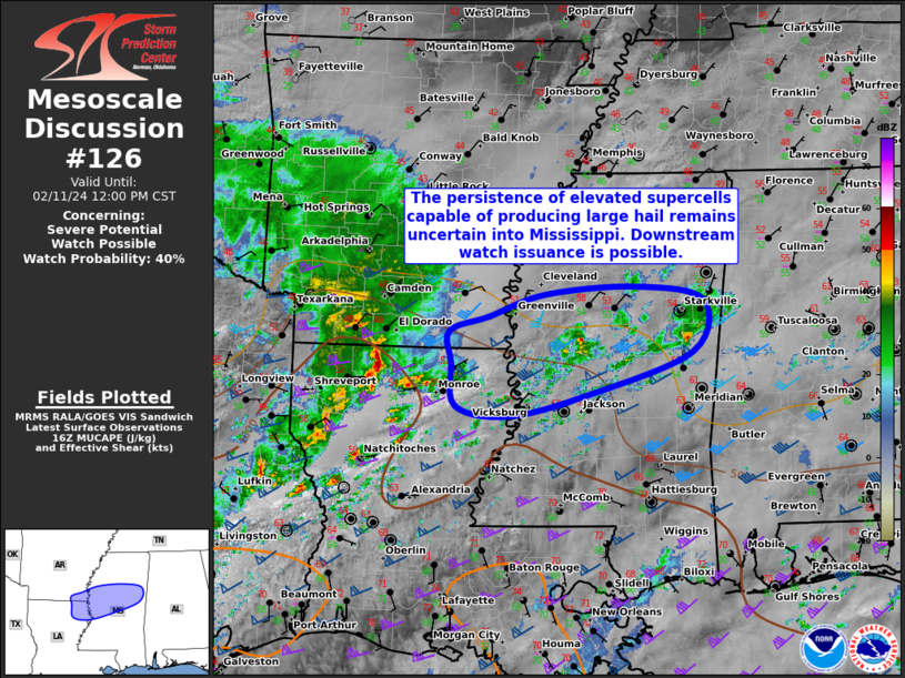
   Mesoscale Discussion 0126
   NWS Storm Prediction Center Norman OK
   1025 AM CST Sun Feb 11 2024

   Areas affected...Portions of northeast LA...far southeast AR...and
   central MS

   Concerning...Severe potential...Watch possible

   Valid 111625Z - 111800Z

   Probability of Watch Issuance...40 percent

   SUMMARY...The persistence of elevated supercells capable of
   producing large hail remains uncertain into Mississippi. Downstream
   watch issuance is possible, but will remain dependent on convective
   trends.

   DISCUSSION...An elevated supercell across northern LA produced
   numerous reports of large hail around 1.5 - 2.5 inches in diameter
   as it moved across Shreveport LA earlier this morning. This activity
   has since weakened slightly and become more linear, as it may be
   outpacing the better mid-level lapse rates plume and greater MUCAPE
   available across east TX into central LA. Still, ample deep-layer
   shear of 50-60 kt will support continued updraft organization with
   any convection that can strengthen and persist along/north of a
   surface front draped across central LA/MS. So long as these
   thunderstorms remain clearly elevated, large hail would remain the
   primary severe risk. Given that MUCAPE is only slowly increasing
   along/north of the boundary into central MS, it remains unclear
   whether the threat for large hail will become sufficient enough to
   justify Severe Thunderstorm Watch issuance with elevated supercells.
   Greater tornado potential is expected to remain along/south of the
   front, and will be addressed in a separate Mesoscale Discussion
   later.

   ..Gleason/Thompson.. 02/11/2024

   ...Please see www.spc.noaa.gov for graphic product...

   ATTN...WFO...JAN...

   LAT...LON   33199195 33379140 33619066 33708946 33568853 32978867
               32499005 32249113 32349185 32849192 33199195
|
|
Top/All Mesoscale Discussions/Forecast Products/Home
|
|


 @NWSSPC