|
| Mesoscale Discussion 40 |
|
< Previous MD Next MD >
|
|
Mesoscale Discussion 0040
NWS Storm Prediction Center Norman OK
0625 PM CST Tue Jan 09 2024
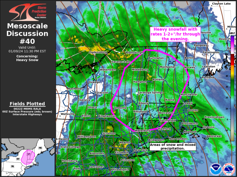
Areas affected...Western New York...and portions of New England
Concerning...Heavy snow
Valid 100025Z - 100430Z
SUMMARY...Heavy snowfall with rates 1-2+"/hr through the evening.
DISCUSSION...A surface low continues to lift northeastward across
southern Michigan. Deep moisture and strong ascent have overspread
portions of the northeast into New England where heavy snow has been
reported. HREF ensemble guidance indicates high probability that
heavy snow will continue across this region through the evening,
with potential for 1-2+"/hr rates at times. Strong warm air
advection from the southeast is ongoing at this hour, with a
transition zone where warmer temperatures are located to the
southeast of the heavier snowfall. Mixed precipitation will likely
continue in this region with lower elevations changing back over to
rain through the evening. Heavy snow will spread north and east
through New England the evening and overnight.
..Thornton.. 01/10/2024
...Please see www.spc.noaa.gov for graphic product...
ATTN...WFO...GYX...BOX...BTV...OKX...ALY...BGM...
LAT...LON 42137198 41737256 41617329 41607397 41897451 42107491
42367515 42697522 43427475 44137449 44897332 44847258
44637188 44187113 43787093 43557103 42387179 42137198
|
|
Top/All Mesoscale Discussions/Forecast Products/Home
|
|


 @NWSSPC