|
| Mesoscale Discussion 706 |
|
< Previous MD Next MD >
|
|
Mesoscale Discussion 0706
NWS Storm Prediction Center Norman OK
0258 PM CDT Wed May 08 2024
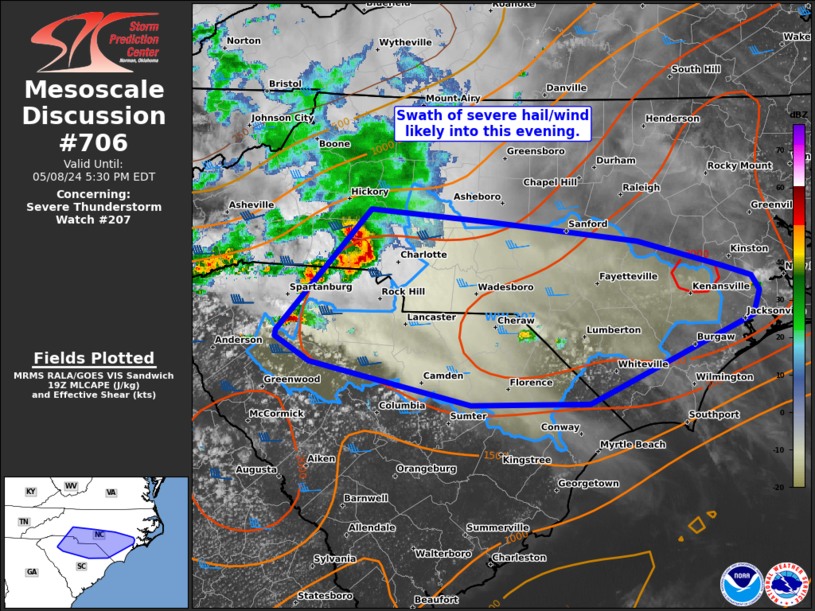
Areas affected...Southern NC and northern SC
Concerning...Severe Thunderstorm Watch 207...
Valid 081958Z - 082130Z
The severe weather threat for Severe Thunderstorm Watch 207
continues.
SUMMARY...A swath of large hail from 1-1.75 inches in diameter and
damaging winds of 55-70 mph will remain likely as organized clusters
across western parts of North Carolina and South Carolina progress
east into this evening.
DISCUSSION...An organized, outflow-dominated cluster is currently
approaching Charlotte, while a separate supercell exists south of
Spartanburg. Low-level shear/SRH remains quite weak in area VWP
data, suggesting that this outflow-dominated evolution will persist
downstream across the rest of the Piedmont towards the coastal
plain. With surface temperatures peaking in the upper 80s to low
90s, MLCAPE of 2000-2500 J/kg has become common. With enhanced
westerly mid/upper flow over the southern Appalachians, a continued
severe hail/wind threat is expected straddling the Carolina border
area for the next several hours.
..Grams.. 05/08/2024
...Please see www.spc.noaa.gov for graphic product...
ATTN...WFO...MHX...RAH...ILM...CAE...GSP...
LAT...LON 35648110 35557992 35387847 35187763 35097735 34987728
34787734 34067894 34058012 34418171 34618204 34658203
35648110
|
|
Top/All Mesoscale Discussions/Forecast Products/Home
|
|


 @NWSSPC