|
| Mesoscale Discussion 694 |
|
< Previous MD Next MD >
|
|
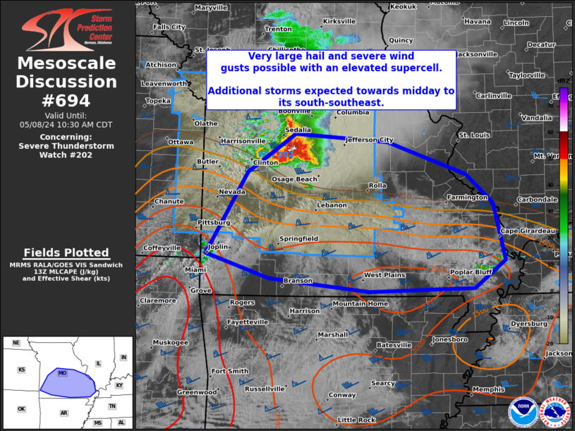
   Mesoscale Discussion 0694
   NWS Storm Prediction Center Norman OK
   0858 AM CDT Wed May 08 2024

   Areas affected...central to southeast MO

   Concerning...Severe Thunderstorm Watch 202...

   Valid 081358Z - 081530Z

   The severe weather threat for Severe Thunderstorm Watch 202
   continues.

   SUMMARY...An intense elevated supercell is expected to persist into
   midday, east-southeastward along the instability gradient from
   central to southern Missouri, with very large hail as the primary
   short-term threat. This storm and additional convective development
   will necessitate downstream watch issuance in the late morning.

   DISCUSSION...A large elevated supercell with a consistently strong
   and deep circulation will likely persist east-southeast along the
   tight instability gradient across southern MO. MRMS MESH values over
   the past half hour have been suggestive of 2-2.5 inch hail in
   diameter, with up to golf ball size recently reported.  While this
   storm will remain elevated for the next couple hours, the downstream
   boundary layer will destabilize, especially over the MS Valley and
   across far southern MO along the northern edge of at least mid 60s
   surface dew points. It is plausible that this specific supercell
   could eventually impinge on the increasing MLCAPE plume. Additional
   storms will likely form to its immediate south-southeast through
   midday as the low-level warm advection regime shifts east. This
   would result in a greater damaging wind and eventual tornado threat
   as this process occurs, focused on south-central to southeast MO.

   ..Grams.. 05/08/2024

   ...Please see www.spc.noaa.gov for graphic product...

   ATTN...WFO...PAH...MEG...LSX...SGF...EAX...

   LAT...LON   38719301 38609141 38169007 37758960 36978941 36608994
               36569173 36739344 37079453 38199382 38719301
|
|
Top/All Mesoscale Discussions/Forecast Products/Home
|
|


 @NWSSPC