|
| Mesoscale Discussion 684 |
|
< Previous MD Next MD >
|
|
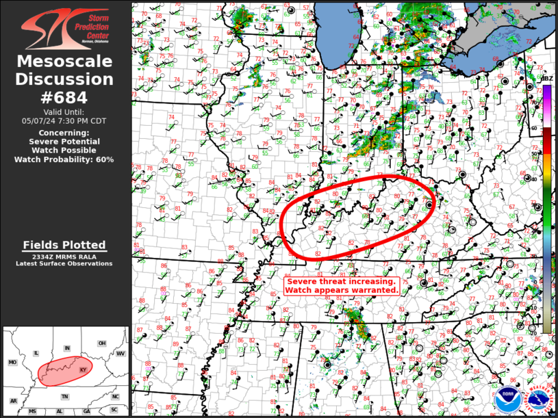
   Mesoscale Discussion 0684
   NWS Storm Prediction Center Norman OK
   0636 PM CDT Tue May 07 2024

   Areas affected...Ohio Valley

   Concerning...Severe potential...Watch possible

   Valid 072336Z - 080030Z

   Probability of Watch Issuance...60 percent

   SUMMARY...Severe threat appears to be increasing across the southern
   Ohio Valley this evening. New watch appears warranted and may be
   issued by soon.

   DISCUSSION...Persistent corridor of low-level confluence extends
   along the confluence of the MS/OH River into southern IN. Agitated
   cu field is gradually deepening across southern IL/IN into western
   KY where MLCAPE values are in excess of 3000 J/kg. Given the strong,
   deep-layer shear across this region, robust updrafts may evolve over
   the next few hours. Supercell risk is increasing and a new ww
   appears warranted.

   ..Darrow/Hart.. 05/07/2024

   ...Please see www.spc.noaa.gov for graphic product...

   ATTN...WFO...JKL...ILN...LMK...IND...PAH...

   LAT...LON   38118851 38848542 38318387 37448453 36668753 37068870
               38118851
|
|
Top/All Mesoscale Discussions/Forecast Products/Home
|
|


 @NWSSPC