|
| Mesoscale Discussion 654 |
|
< Previous MD Next MD >
|
|
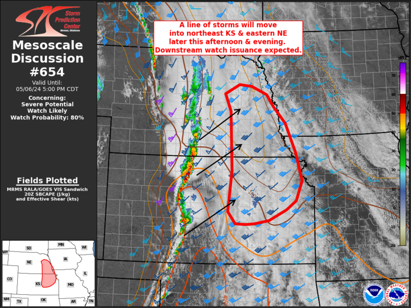
   Mesoscale Discussion 0654
   NWS Storm Prediction Center Norman OK
   0307 PM CDT Mon May 06 2024

   Areas affected...Eastern Nebraska and northeast Kansas

   Concerning...Severe potential...Watch likely

   Valid 062007Z - 062200Z

   Probability of Watch Issuance...80 percent

   SUMMARY...Ongoing thunderstorms across WW 187 are expected to exit
   the eastern edge of the watch by around 22 UTC. Although the
   downstream environment is currently fairly stable, sufficient
   destabilization is anticipated to maintain the severe threat and
   warrant watch issuance across parts of eastern Nebraska and
   northeast Kansas.

   DISCUSSION...Regional radar imagery over the past hour has shown an
   organizing band of storms across southern NE into central KS. Nearly
   all convective trends have shown signs of intensification amid
   continued destabilization and persistent synoptic ascent over the
   region. Recent estimates suggest that this line will reach the
   eastern portions of WW 187 by around 22 UTC. Downstream, persistent
   cloud cover has limited diurnal heating with substantial lingering
   SBCIN (around -150 to -250 J/kg per recent RAP mesoanalysis). It
   remains uncertain how much clearing will occur ahead of the line,
   but continued deep-layer ascent should help steepen mid-level lapse
   rates and slowly erode residual capping. Additionally, strong (40-50
   knot) deep-layer wind shear with amalgamating/deepening cold pools
   should maintain storm organization. Consequently, the expectation is
   for this line to maintain severe intensity as it migrates east.
   Low-level wind profiles downstream should be conducive for not only
   severe gusts, but embedded circulations as well. Downstream watch
   issuance will likely be needed within the next hour or so to account
   for this threat.

   ..Moore/Smith.. 05/06/2024

   ...Please see www.spc.noaa.gov for graphic product...

   ATTN...WFO...EAX...OAX...TOP...ICT...GID...

   LAT...LON   38469771 39619757 41289763 41779784 42029730 41989686
               41759631 41419605 40959562 40129525 39329503 38769525
               38519561 38229624 38139676 38119708 38139744 38469771
|
|
Top/All Mesoscale Discussions/Forecast Products/Home
|
|


 @NWSSPC