|
| Mesoscale Discussion 611 |
|
< Previous MD Next MD >
|
|
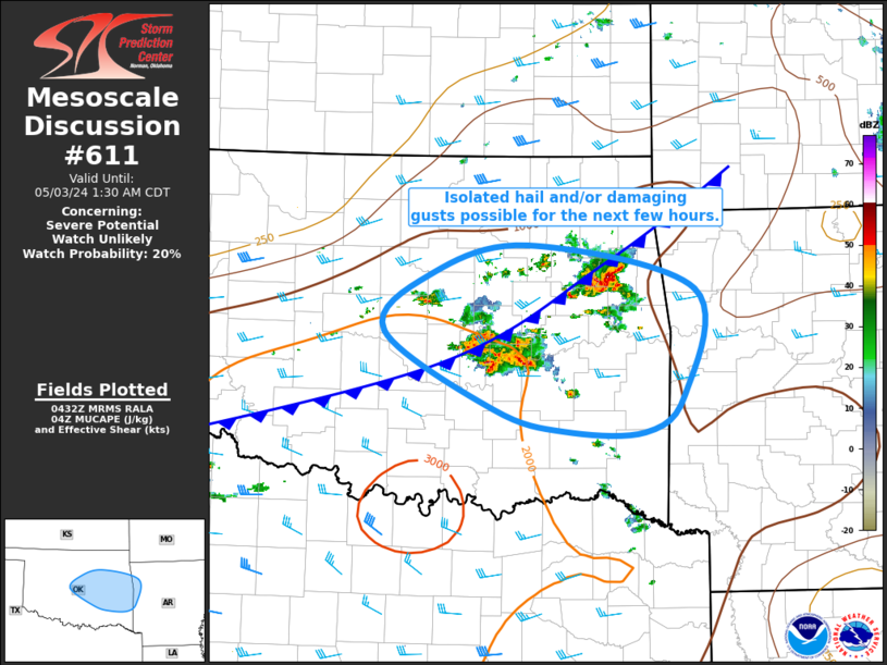
   Mesoscale Discussion 0611
   NWS Storm Prediction Center Norman OK
   1134 PM CDT Thu May 02 2024

   Areas affected...Central and East-Central OK into Far West-Central
   AR

   Concerning...Severe potential...Watch unlikely

   Valid 030434Z - 030630Z

   Probability of Watch Issuance...20 percent

   SUMMARY...Isolated hail and/or damaging gusts possible for the next
   few hours across central and east-central Oklahoma.

   DISCUSSION...The combination of modest ascent along a
   southward-moving cold front and weak warm-air advection has lead to
   the increase in predominantly multicellular thunderstorm across
   central and east-central OK. Deep-layer vertical shear is modest,
   which is expected to keep updraft organization minimal. Even so,
   relatively cold mid-level temperatures, helping support max lapse
   rates in the 2-6 km layer around 7 deg C per km. These are steep
   enough to support moderate buoyancy and the potential for a few
   updrafts strong enough to produce small hail. Elevated character to
   most of the storms should limit the wind gusts threat, but
   interaction with the front and/or with other storms could lead to a
   few stronger gusts (as recently observed with the storm over Wagoner
   and Cherokee Counties).

   ..Mosier/Guyer.. 05/03/2024

   ...Please see www.spc.noaa.gov for graphic product...

   ATTN...WFO...LZK...SHV...TSA...OUN...

   LAT...LON   34699640 35399761 35909713 36189602 35789415 34819427
               34489471 34489562 34699640
|
|
Top/All Mesoscale Discussions/Forecast Products/Home
|
|


 @NWSSPC