|
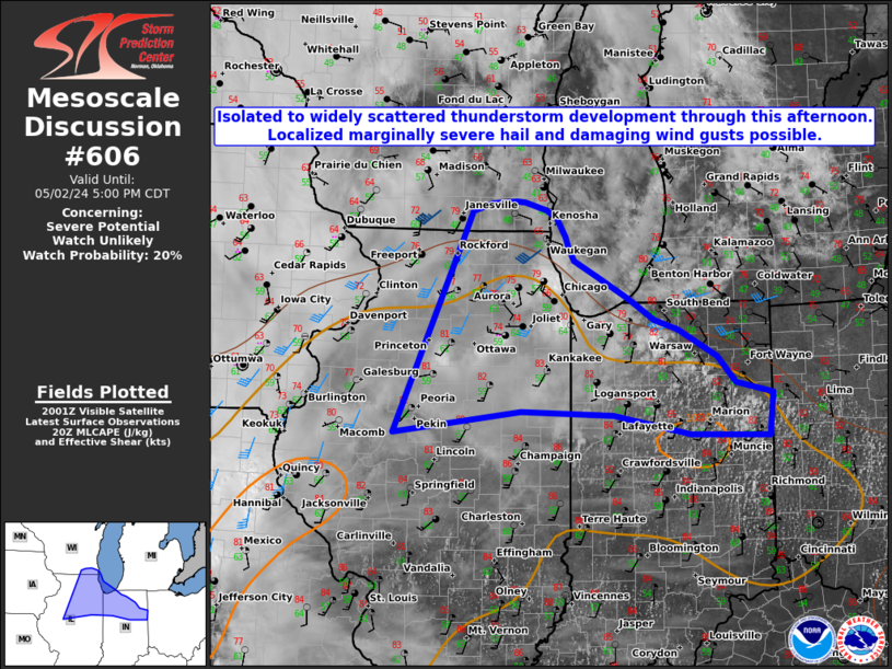
| Mesoscale Discussion 606 |
|
< Previous MD Next MD >
|
|
   Mesoscale Discussion 0606
   NWS Storm Prediction Center Norman OK
   0307 PM CDT Thu May 02 2024

   Areas affected...Portions of northeast Illinois and northern Indiana

   Concerning...Severe potential...Watch unlikely

   Valid 022007Z - 022200Z

   Probability of Watch Issuance...20 percent

   SUMMARY...Widely scattered thunderstorms are expected to continue
   through this afternoon across portions of northern Illinois and
   Indiana. A few thunderstorms could produce hail of 1-1.25 inches in
   diameter and wind gusts near 60 mph.

   DISCUSSION...Recent radar trends show an area of deep moist
   convection developing along a warm front lifting northward across
   northern Indiana and Illinois. Meanwhile, aloft, a mid to upper
   level shortwave trough apparent in water vapor imagery now crossing
   the Dakotas and an associated mid level jet max were progressing
   east northeastward. Buoyancy behind the warm front will continue to
   increase through late this afternoon, along with a slow increase in
   mid to upper flow/deep effective shear via the shortwave trough to
   the northwest. However, most of the large scale ascent associated
   with the latter will remain well northwest of the unstable air mass
   and severe convective coverage is expected to remain rather limited.
   Some updraft intensification could occur within a few cells that
   manage to avoid interactions through peak daytime heating. Any of
   these more robust thunderstorms that manage to develop could briefly
   become severe.

   ..Barnes/Lyons/Hart.. 05/02/2024

   ...Please see www.spc.noaa.gov for graphic product...

   ATTN...WFO...IWX...IND...LOT...ILX...MKX...DVN...

   LAT...LON   40418993 42418899 42698886 42778860 42798826 42788814
               42718785 42638772 42438760 42308755 42188748 42028716
               41798673 41588638 41488607 41198554 40928528 40818479
               40388484 40398590 40608695 40638820 40418993
|
|
Top/All Mesoscale Discussions/Forecast Products/Home
|
|


 @NWSSPC