|
| Mesoscale Discussion 512 |
|
< Previous MD Next MD >
|
|
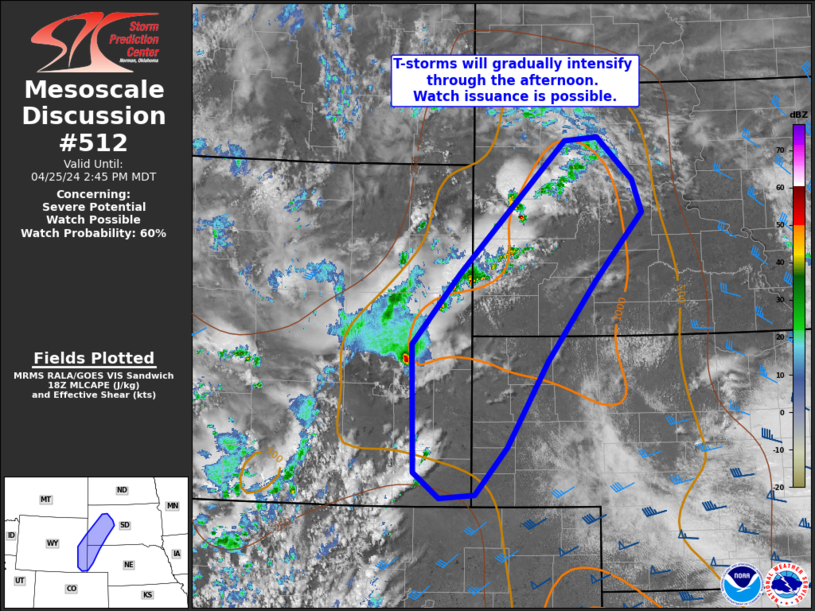
   Mesoscale Discussion 0512
   NWS Storm Prediction Center Norman OK
   0151 PM CDT Thu Apr 25 2024

   Areas affected...Southeast Wyoming into South Dakota and northwest
   Nebraska

   Concerning...Severe potential...Watch possible

   Valid 251851Z - 252045Z

   Probability of Watch Issuance...60 percent

   SUMMARY...Thunderstorms are expected to gradually intensify through
   the afternoon hours across parts of southeast Wyoming, western South
   Dakota, and northwest Nebraska. This activity will primarily pose a
   severe hail risk, though a few severe gusts are also possible.

   DISCUSSION...Over the past 1-2 hours, high-based convection
   developing off the higher terrain of central WY, along with
   additional convection along a deepening surface trough, has migrated
   into a narrow plume of returning moisture noted in surface
   observations (dewpoints in the low to mid 50s). Steep lapse rates
   between 8-9 C/km noted in 12 UTC soundings remain entrenched over
   the region with upper-level ascent increasing with the approach of
   synoptic wave from the southwest. This combination of improving
   moisture and steep lapse rates is supporting MLCAPE values upwards
   of 1000 J/kg over a region with increasing ascent. Consequently,
   thunderstorm coverage and intensity is forecast to increase through
   the afternoon. While stronger mid-level flow is displaced to the
   south, elongated hodographs featuring 30 knot winds near the 6 km
   level should support organization of semi-discrete cells and
   thunderstorm clusters with an attendant threat for large hail (most
   likely between 0.75 to 1.5 inches in diameter). Additionally, 20-30
   F dewpoint depressions indicate steep low-level lapse rates that
   should support the potential for a few severe gusts - especially if
   a more organized cluster with a consolidated cold pool can become
   established.

   ..Moore/Hart.. 04/25/2024

   ...Please see www.spc.noaa.gov for graphic product...

   ATTN...WFO...LBF...UNR...CYS...

   LAT...LON   41400497 42890500 43730424 45270256 45320203 44820147
               44430131 43640208 42700284 41700349 41140400 41100456
               41400497
|
|
Top/All Mesoscale Discussions/Forecast Products/Home
|
|


 @NWSSPC