|
| Mesoscale Discussion 488 |
|
< Previous MD Next MD >
|
|
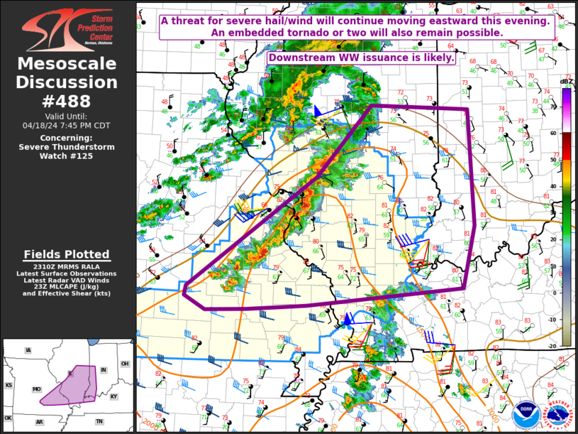
   Mesoscale Discussion 0488
   NWS Storm Prediction Center Norman OK
   0612 PM CDT Thu Apr 18 2024

   Areas affected...Southeast MO into southern IL...extreme southwest
   IN...and western KY

   Concerning...Severe Thunderstorm Watch 125...

   Valid 182312Z - 190045Z

   The severe weather threat for Severe Thunderstorm Watch 125
   continues.

   SUMMARY...The threat for severe hail and wind, along with an
   embedded tornado or two, will spread quickly eastward this evening.
   Eventual downstream watch issuance is likely.

   DISCUSSION...A broken line of thunderstorms moving across
   east-central/southeast MO into southwest IL has shown signs of
   accelerating eastward early this evening, as new cells have merged
   into the line near/north of the St. Louis area. Increasing outbound
   velocities have been noted from the KLSX radar, and damaging wind
   gusts of 60-75 mph may become an increasing threat through the
   evening as the line of storms moves quickly eastward into a region
   where modestly strong heating occurred this afternoon. Meanwhile,
   moderate instability will continue to support a hail threat with any
   embedded supercells. A modest increase in low-level flow/shear is
   expected ahead of the line this evening into south-central/southeast
   IL and southwest IN, which will support a threat of an tornado or
   two, both with any embedded supercells, and also with stronger QLCS
   mesovortices.

   The line of storms will likely approach the edge of WW 125 between
   00-01Z, with downstream watch issuance likely into parts of
   southeast IL and southwest IN.

   ..Dean/Guyer.. 04/18/2024

   ...Please see www.spc.noaa.gov for graphic product...

   ATTN...WFO...LMK...IND...PAH...ILX...LSX...SGF...

   LAT...LON   37419215 37559213 39158977 40178876 40108698 38448689
               37538711 37338950 37308993 37289030 37249102 37229177
               37419215
|
|
Top/All Mesoscale Discussions/Forecast Products/Home
|
|


 @NWSSPC