|
| Mesoscale Discussion 426 |
|
< Previous MD Next MD >
|
|
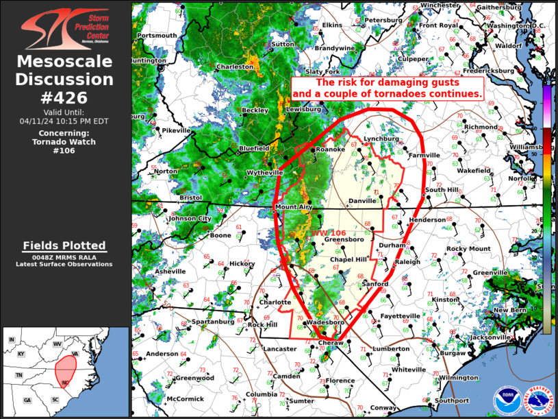
   Mesoscale Discussion 0426
   NWS Storm Prediction Center Norman OK
   0751 PM CDT Thu Apr 11 2024

   Areas affected...Portions of western North Carolina and southern
   Virginia

   Concerning...Tornado Watch 106...

   Valid 120051Z - 120215Z

   The severe weather threat for Tornado Watch 106 continues.

   SUMMARY...The risk for damaging gusts and a couple of tornadoes will
   continue this evening. Short bowing segments and a few supercells
   should continue into south-central VA and central NC tonight. Some
   guidance suggests the severe threat may persist beyond WW106 this
   evening.

   DISCUSSION...As of 0040 UTC, ongoing storms over portions of NC/VA
   have produced several reports of damage. Storm organization has
   trended towards more liner structures over the last couple of hours
   owing to numerous storm interactions. However, more clustered
   cellular elements have persisted to the south. The environment ahead
   of these storms across parts of south-central VA and west-central NC
   remains modestly unstable and strongly sheared with ESRH of 250-400
   m2/s2. Rotating structures within the line and broader cluster will
   likely remain capable of damaging gusts and a couple of tornadoes
   into this evening. Recent HRRR guidance also suggests these storms
   may continue to pose a severe risk across parts of southern VA and
   central NC later this evening. While it is somewhat unclear how far
   north/east the risk may continue this evening with weakening
   buoyancy and nocturnal cooling, the general environment remains
   favorable. Mesoscale trends will be monitored for the need of a
   downstream watch should storms maintain intensity.

   ..Lyons/Thompson.. 04/12/2024

   ...Please see www.spc.noaa.gov for graphic product...

   ATTN...WFO...AKQ...LWX...RAH...ILM...RNK...GSP...

   LAT...LON   35677867 34767954 34847983 35118001 35498028 35838043
               36088053 36538059 37068051 37727950 37877904 37857862
               37717830 37487815 37127810 36667814 36527822 36007850
               35677867
|
|
Top/All Mesoscale Discussions/Forecast Products/Home
|
|


 @NWSSPC