|
| Mesoscale Discussion 411 |
|
< Previous MD Next MD >
|
|
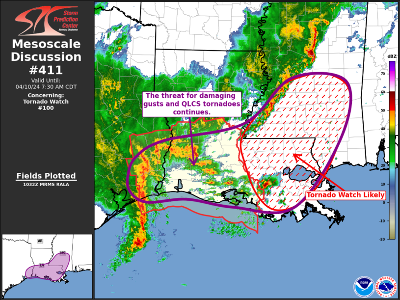
   Mesoscale Discussion 0411
   NWS Storm Prediction Center Norman OK
   0535 AM CDT Wed Apr 10 2024

   Areas affected...Far Southeast TX...Southern LA...Central/Southern
   MS

   Concerning...Tornado Watch 100...

   Valid 101035Z - 101230Z

   The severe weather threat for Tornado Watch 100 continues.

   SUMMARY...Strong wind gusts and line-embedded tornadoes remain
   possible across far southeast Texas and southwest Louisiana.
   Additionally, the tornado threat appears to be increasing across
   southeast Louisiana and southern Mississippi, where a Tornado Watch
   will be needed soon

   DISCUSSION...Ongoing convective line continues to move quickly
   across far southeast TX. Recent radar imagery has shown an increase
   in echo tops within the line, with a bookend vortex also becoming
   more observable. This line is now more favorably oriented with the
   deep-layer vertical shear vector and the downstream air mass remains
   moist and unstable. As such, the line is expected to continue
   progresses eastward into southwest LA, with some potential
   intensification possible. Primary threat remains strong gusts (60-80
   mph), but embedded QLCS tornadoes are possible as well.

   Farther east, a blossoming warm-air advection regime is contributing
   to increasing storm coverage and intensity. Storm in Assumption
   Parish has a strong updraft with modest supercellular
   characteristics. This trend for increasing storm coverage and
   intensity will likely spread northward/northeastward into more of
   southeast LA and eventually into southern MS. The parameter space
   supports supercells capable of all severe hazards and Tornado Watch
   will likely be needed soon.

   ..Mosier/Smith.. 04/10/2024

   ...Please see www.spc.noaa.gov for graphic product...

   ATTN...WFO...MOB...JAN...LIX...LCH...HGX...

   LAT...LON   29429189 29599311 29509413 29739459 30079467 30529448
               30929373 31339162 32379032 32288886 31078899 29439029
               29429189
|
|
Top/All Mesoscale Discussions/Forecast Products/Home
|
|


 @NWSSPC