|
| Mesoscale Discussion 393 |
|
< Previous MD Next MD >
|
|
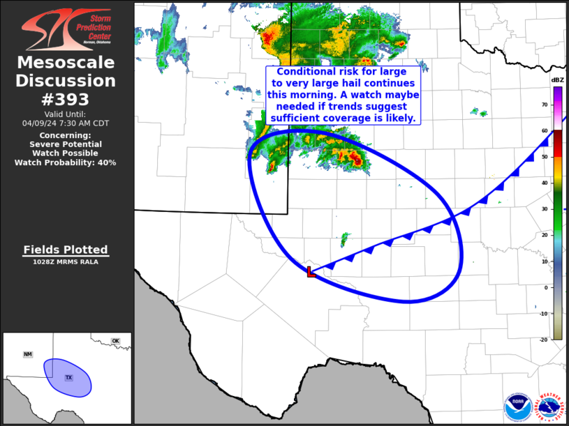
   Mesoscale Discussion 0393
   NWS Storm Prediction Center Norman OK
   0530 AM CDT Tue Apr 09 2024

   Areas affected...Southwest TX into the Permian Basin and Far
   Southeast NM

   Concerning...Severe potential...Watch possible

   Valid 091030Z - 091230Z

   Probability of Watch Issuance...40 percent

   SUMMARY...Conditional risk for large to very large hail will
   continue from far southeast New Mexico into the Permian Basin and
   southwest Texas this morning. A watch may be needed if trends
   suggest sufficient storm coverage is likely.

   DISCUSSION...Elevated thunderstorms continue across far southeast NM
   and the TX South Plains amid persistent warm-air advection to the
   north of a  surface low centered over the Pecos County TX vicinity.
   Large hail will remain possible with these storms over the next hour
   or two.

   Farther south, a recent attempt at deep convection near the center
   of the low over Crane, Midland, and Upton Counties in TX failed, but
   additional attempts are expected in this area as surface convergence
   persists and large-scale forcing for ascent gradually increases.
   Steep mid-level lapse rates and robust deep-layer vertical shear
   across this region would support strong updrafts capable of large to
   very large hail with any sustained development. Primary uncertainty
   is whether or not updrafts can be sustained amid the substantial
   low/mid-level dry air in place. Given the conditional risk for large
   to very large hail and potential need for a watch, observational
   data and convective trends will be monitored closely over the next
   couple of hours for signs that deeper convection can be maintained.

   ..Mosier/Smith.. 04/09/2024

   ...Please see www.spc.noaa.gov for graphic product...

   ATTN...WFO...SJT...LUB...MAF...

   LAT...LON   32900372 33200238 32290045 31150010 30700107 31330298
               32900372
|
|
Top/All Mesoscale Discussions/Forecast Products/Home
|
|


 @NWSSPC