|
| Mesoscale Discussion 391 |
|
< Previous MD Next MD >
|
|
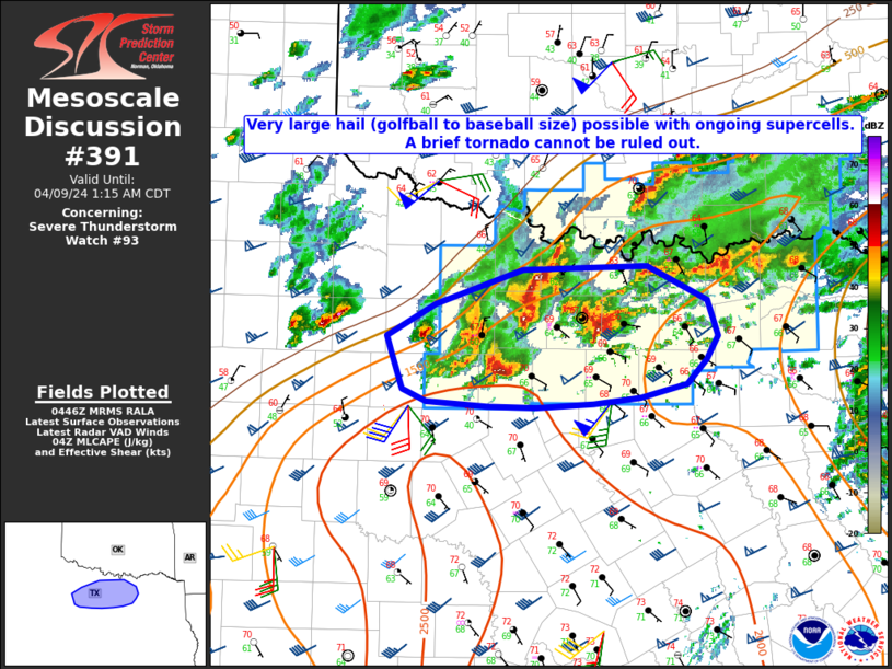
   Mesoscale Discussion 0391
   NWS Storm Prediction Center Norman OK
   1149 PM CDT Mon Apr 08 2024

   Areas affected...Parts of north TX

   Concerning...Severe Thunderstorm Watch 93...

   Valid 090449Z - 090615Z

   The severe weather threat for Severe Thunderstorm Watch 93
   continues.

   SUMMARY...Very large hail (golfball to baseball size) remains
   possible with an ongoing supercell cluster. A brief tornado cannot
   be ruled out.

   DISCUSSION...Several supercells are ongoing at 0445 UTC to the
   west-northwest of the Metroplex, with multiple cells having produced
   golfball or larger sized hail (up to 3 inches in diameter) within
   the last hour. While some cell interactions/mergers have been noted
   with the northernmost cells, the two right-moving supercells ongoing
   west of Mineral Wells and north of Fort Worth may be able to move
   east-northeastward with minimal interference in the short term.

   MLCAPE of around 2000 J/kg and effective shear of 45-55 kt will
   continue to support supercell potential into the early overnight
   hours, with very large hail (potentially 2-3 inches in diameter with
   the strongest cells) as the primary threat, along with some risk for
   localized severe gusts. Also, low-level flow has substantially
   increased over the last 1-2 hours on the KFWS VWP, with 0-1 km SRH
   increasing above 150 m2/s2. This could support a brief tornado
   threat with the strongest right-moving cells, though relatively cool
   near-surface conditions may mitigate this threat to some extent.

   ..Dean.. 04/09/2024

   ...Please see www.spc.noaa.gov for graphic product...

   ATTN...WFO...FWD...OUN...SJT...

   LAT...LON   33359899 33639814 33679694 33399637 33109626 32919638
               32709657 32609701 32549747 32529802 32539848 32579908
               32679931 32979941 33099945 33359899
|
|
Top/All Mesoscale Discussions/Forecast Products/Home
|
|


 @NWSSPC