|
| Mesoscale Discussion 379 |
|
< Previous MD Next MD >
|
|
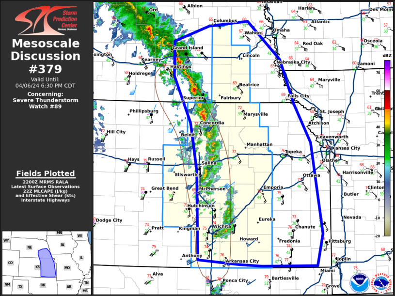
   Mesoscale Discussion 0379
   NWS Storm Prediction Center Norman OK
   0503 PM CDT Sat Apr 06 2024

   Areas affected...southeast Nebraska and eastern Kansas

   Concerning...Severe Thunderstorm Watch 89...

   Valid 062203Z - 062330Z

   The severe weather threat for Severe Thunderstorm Watch 89
   continues.

   SUMMARY...A line of storms will continue to produce severe wind
   gusts this evening.

   DISCUSSION...A line of low-topped storms continues to race east
   across the Plains. Limited buoyancy is limiting the overall threat,
   but the forced line of storms amid a very strong wind field has
   proven sufficient to mix severe wind gusts to the surface as storms
   pass. Expect this to continue for a few more hours before storms
   outrun the better low-level moisture and surface temperatures cool.
   Given the expectation for weakening storms by mid evening, a
   downstream watch is unlikely.

   ..Bentley/Hart.. 04/06/2024

   ...Please see www.spc.noaa.gov for graphic product...

   ATTN...WFO...SGF...EAX...OAX...TOP...ICT...GID...

   LAT...LON   37149764 38759769 39639785 40479825 41109825 41389744
               41479652 40779574 39999544 39279504 37619479 37029492
               37039619 37069672 37149764
|
|
Top/All Mesoscale Discussions/Forecast Products/Home
|
|


 @NWSSPC