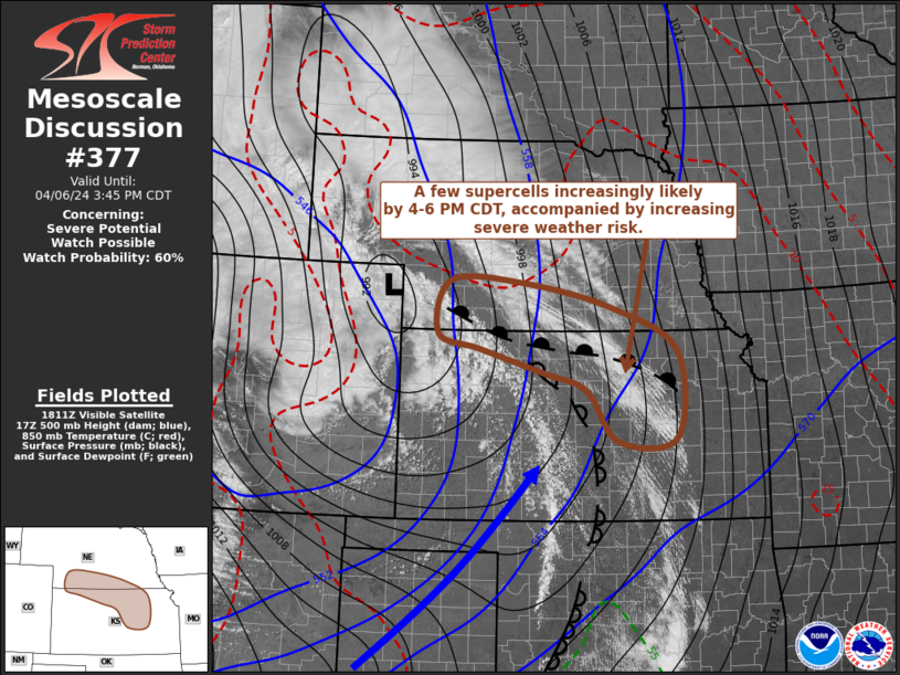
   Mesoscale Discussion 0377
   NWS Storm Prediction Center Norman OK
   0119 PM CDT Sat Apr 06 2024

   Areas affected...parts of southern Nebraska...northern and central
   Kansas

   Concerning...Severe potential...Watch possible

   Valid 061819Z - 062045Z

   Probability of Watch Issuance...60 percent

   SUMMARY...Thunderstorms are expected to gradually develop and
   intensify this afternoon, eventually posing at least some risk for
   severe wind and hail.  By 4-6 PM CDT, this may include increasing
   potential for supercells, east of Hill City into the Concordia
   vicinity and southward toward Emporia.

   DISCUSSION...One short wave perturbation already appears to have
   emerged from the base of larger-scale mid/upper troughing
   progressing out of the Great Basin/Southwest, and is now pivoting
   north-northeast of the Front Range.  In its wake, an intense
   mid-level jet streak currently nosing across the Texas/Oklahoma
   Panhandle vicinity may undergo subtle weakening, but still appears
   likely to remain in excess of 90 kt around 500 mb, while taking on
   more of a west-southwesterly component as it propagates toward the
   Russell/Hutchinson vicinity of central Kansas through 21-23Z.

   Stronger forcing for ascent is forecast to become focused along the
   warm frontal zone associated with a deep occluding cyclone to the
   lee of the Front Range, roughly near the western Nebraska/Kansas
   border vicinity during the next few hours.  This appears likely to
   coincide with increasing destabilization, associated with a
   deepening mixed boundary-layer to the south of the front.  Warm
   sector boundary-layer moistening will remain on lower margins for
   vigorous convective development, but lower/mid 40s along the warm
   front may be sufficient for CAPE up to 500 J/kg, beneath relatively
   cool mid-level temperatures (near -20C around 500 mb).

   Scattered thunderstorms are already beginning to initiate across
   parts of the high plains.  In the presence of strong deep-layer
   shear, forcing for ascent may gradually focus stronger, organizing
   convection near the triple point of the occluding cyclone,
   north-northeast of the Hill City vicinity, before this spreads
   eastward through late afternoon.

   By 21-23Z, it appears that additional, more discrete storms
   (including evolving supercells) may gradually begin to initiate
   southward along the dryline toward the Wichita area, within a narrow
   corridor of better boundary-layer moistening (including surface dew
   points in the upper 40s/near 50F).

   ..Kerr/Guyer.. 04/06/2024

   ...Please see www.spc.noaa.gov for graphic product...

   ATTN...WFO...OAX...TOP...ICT...GID...LBF...GLD...

   LAT...LON   39339911 39710042 39950128 40790103 40749951 40359770
               39689640 38309642 38259761 39069826 39339911
|


 @NWSSPC