|
| Mesoscale Discussion 374 |
|
< Previous MD Next MD >
|
|
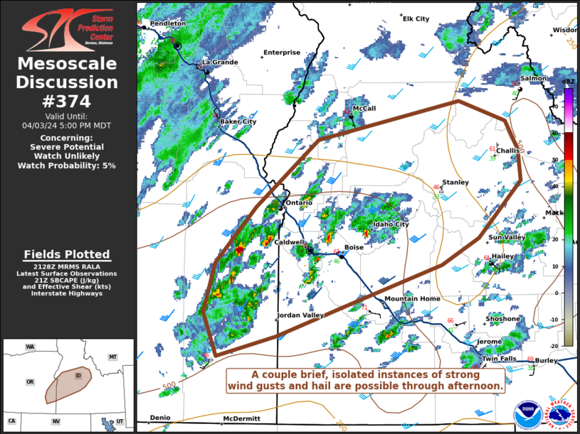
   Mesoscale Discussion 0374
   NWS Storm Prediction Center Norman OK
   0431 PM CDT Wed Apr 03 2024

   Areas affected...portions of far eastern Oregon into western and
   central Idaho

   Concerning...Severe potential...Watch unlikely

   Valid 032131Z - 032300Z

   Probability of Watch Issuance...5 percent

   SUMMARY...Isolated strong wind gusts and instances of hail may
   accompany the stronger storms this afternoon into early evening. The
   severe threat is expected to be sparse and localized.

   DISCUSSION...Multiple pulse cellular storms and multicells have
   recently developed to the east of a cloud deck in the past couple of
   hours over far eastern OR into southwestern ID. Here, diurnal
   heating has encouraged surface temperatures to warm into the mid 60s
   F amid mid 30s-40s F dewpoints, that in tandem with steep lapse
   rates, has boosted SBCAPE to 500-1000 J/kg. RAP forecast soundings
   and regional VADs depict curved, elongated hodographs, indicating
   the presence of strong deep-layer shear, with 21Z mesoanalysis
   depicting over 40 kts of effective bulk shear. Forecast soundings
   show thin CAPE profiles atop a dry, well-mixed boundary layer. As
   such, brief and localized instances of strong wind gusts and perhaps
   some hail may occur with the stronger multicells or any transient
   supercells that can develop. Nonetheless, the severe threat is
   expected to remain isolated.

   ..Squitieri/Guyer.. 04/03/2024

   ...Please see www.spc.noaa.gov for graphic product...

   ATTN...WFO...PIH...MSO...BOI...

   LAT...LON   42631780 43031797 43501784 44021731 44651652 45021469
               44831408 44551392 44271389 43741444 43491492 43161597
               42811705 42631780
|
|
Top/All Mesoscale Discussions/Forecast Products/Home
|
|


 @NWSSPC