|
| Mesoscale Discussion 364 |
|
< Previous MD Next MD >
|
|
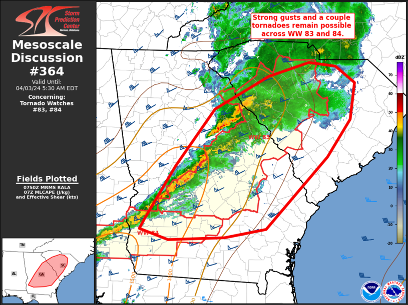
   Mesoscale Discussion 0364
   NWS Storm Prediction Center Norman OK
   0253 AM CDT Wed Apr 03 2024

   Areas affected...portions of central/eastern Georgia into South
   Carolina

   Concerning...Tornado Watch 83...84...

   Valid 030753Z - 030930Z

   The severe weather threat for Tornado Watch 83, 84 continues.

   SUMMARY...Strong to severe thunderstorms with an attendant risk for
   damaging gusts and a couple tornadoes will continue to shift east
   across parts of Georgia and South Carolina through early morning.
   Trends being monitored for possible watch issuance downstream from
   Tornado Watch 83.

   DISCUSSION...Stronger surface pressure falls have been noted over GA
   the past couple of hours. This has allowed for some minor backing of
   low-level flow ahead of bowing segments from central to eastern GA
   and several areas of low-level rotation have been noted over the
   past hour. Area VWPs continue to show impressive low-level and deep
   shear supporting supercells. Instability remains modest, but
   sufficient for a continued severe thunderstorm/tornado risk the next
   few hours.

   Downstream from Tornado Watch 83 and 84 across portions of southeast
   GA into the SC Midlands into the Low Country, vertical shear will
   improve with time. However, it is unclear how much further
   destabilization will occur with eastward extent. Organized
   convection will likely persist toward the coast into the morning
   hours, but low-level inhibition and poor lapse rates my limit a more
   robust severe risk. Trends will be monitored for possible downstream
   watch issuance in the next couple of hours.

   ..Leitman.. 04/03/2024

   ...Please see www.spc.noaa.gov for graphic product...

   ATTN...WFO...ILM...CHS...CAE...GSP...JAX...FFC...TAE...

   LAT...LON   33878318 34508196 34778102 34698042 34377998 33678010
               32968063 31588202 31438295 31378419 31588484 31768473
               32788406 33878318
|
|
Top/All Mesoscale Discussions/Forecast Products/Home
|
|


 @NWSSPC