|
| Mesoscale Discussion 358 |
|
< Previous MD Next MD >
|
|
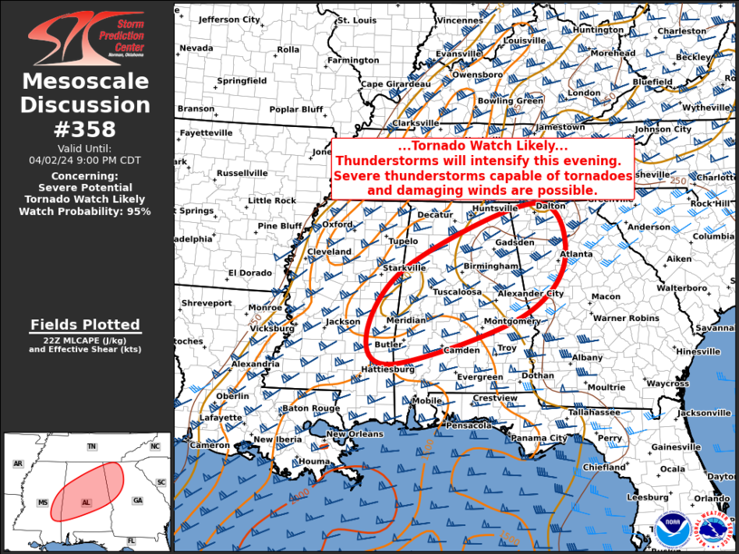
   Mesoscale Discussion 0358
   NWS Storm Prediction Center Norman OK
   0553 PM CDT Tue Apr 02 2024

   Areas affected...Eastern Mississippi...Central Alabama...Northwest
   Georgia

   Concerning...Severe potential...Tornado Watch likely

   Valid 022253Z - 030200Z

   Probability of Watch Issuance...95 percent

   SUMMARY...Thunderstorms will become more numerous through the
   evening, with an increasing risk of tornadoes and damaging winds.
   Watch issuance is expected in the next couple of hours.

   DISCUSSION...A very warm/moist and moderately unstable and only
   weakly capped air mass is in place this evening across much of
   southern MS/AL, with dewpoints in the mid/upper 60s.  Recent
   satellite/radar loops show isolate showers and thunderstorms
   beginning to develop in this region.  Models have been consistent in
   the development of a strong southerly low-level jet by mid-evening,
   resulting in northward advection of the better moisture and
   strengthening low-level wind fields.  Forecast soundings suggest
   rapid enlargement of hodographs after dark, with parameters becoming
   quite favorable for supercells capable of tornadoes and damaging
   winds.  A tornado watch will be needed for parts of this region in
   the next couple of hours as more robust convective initiation
   begins.

   ..Hart/Guyer.. 04/02/2024

   ...Please see www.spc.noaa.gov for graphic product...

   ATTN...WFO...FFC...BMX...HUN...MOB...JAN...

   LAT...LON   32258913 33668809 34968490 33758421 32548536 31578849
               32258913
|
|
Top/All Mesoscale Discussions/Forecast Products/Home
|
|


 @NWSSPC