|
| Mesoscale Discussion 354 |
|
< Previous MD Next MD >
|
|
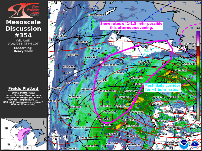
   Mesoscale Discussion 0354
   NWS Storm Prediction Center Norman OK
   0349 PM CDT Tue Apr 02 2024

   Areas affected...portions of eastern Wisconsin and the
   western/central Upper Peninsula of Michigan

   Concerning...Heavy snow

   Valid 022049Z - 030145Z

   SUMMARY...Moderate to heavy snow will gradually expand in coverage
   over parts of WI and MI this afternoon/evening. Rates of 1-1.5
   in/hour are likely within the heaviest banding along the western
   shores of Lake Michigan.

   DISCUSSION...As of 2045 UTC, regional radar and surface analysis
   showed a broad precipitation shield expanding north/northeastward
   from a deepening surface cyclone centered over far northern IL.
   Within this comma head structure, moderate to heavy rain has
   gradually transitioned to snow. While temperatures have been only
   marginally conducive for snow thus far, dynamic cooling and
   low-level cold advection should allow for a full transition to snow
   from west to east. Hi-res forecast guidance suggests the development
   of one or more mesoscale bands is likely through this evening.
   Likely driven by frictional convergence on the western lake shore
   and slantwise convection, snow rates within some of these banded
   structures may reach 1-1.5 in/hr.

   Heavy snow will continue to expand east/northeastward across eastern
   WI and the western UP through the afternoon and into the evening.
   Confidence in the highest rates will remain along the western lake
   shore where forcing for ascent and inland moisture advection are
   expected to be the strongest. However, periodic heavy snowfall with
   rates near 1 in/hr will remain possible across much of WI and the UP
   through tonight.

   ..Lyons.. 04/02/2024

   ...Please see www.spc.noaa.gov for graphic product...

   ATTN...WFO...APX...MQT...GRB...MKX...ARX...

   LAT...LON   46738542 46368505 45948515 45238635 44728699 44108741
               43688788 43628803 43398842 43288870 43218897 43238926
               43718968 44298987 44948978 45448958 45848928 46088894
               46298818 46628682 46708622 46738542
|
|
Top/All Mesoscale Discussions/Forecast Products/Home
|
|


 @NWSSPC