|
| Mesoscale Discussion 344 |
|
< Previous MD Next MD >
|
|
Mesoscale Discussion 0344
NWS Storm Prediction Center Norman OK
0959 AM CDT Tue Apr 02 2024
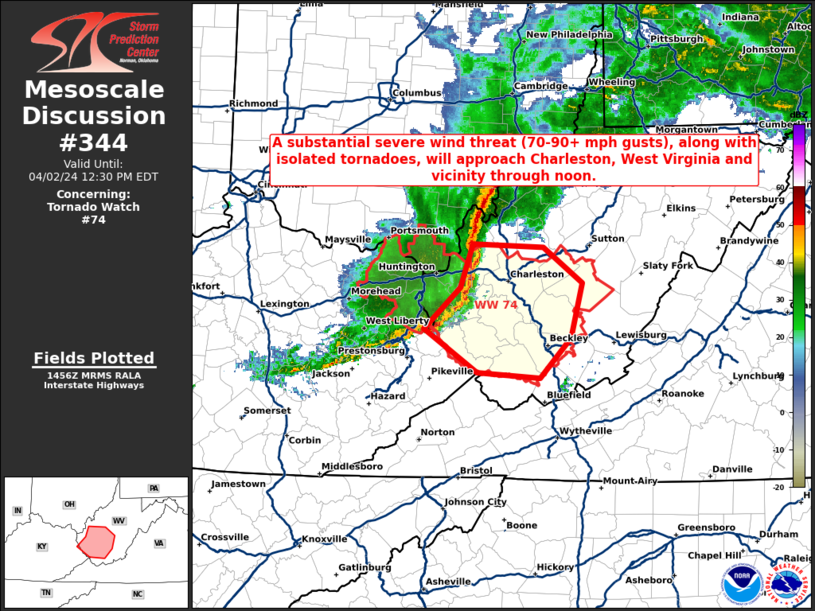
Areas affected...Portions of WV
Concerning...Tornado Watch 74...
Valid 021459Z - 021630Z
The severe weather threat for Tornado Watch 74 continues.
SUMMARY...A substantial severe wind threat (70-90+ mph gusts), along
with isolated tornadoes, will approach Charleston West Virginia and
vicinity through noon.
DISCUSSION...KHTS recently measured a significant severe wind gust
to 80 kt (92 mph) with a compact but well organized cluster
currently moving quickly eastward across parts of WV. Even though
the airmass across this region remains only weakly unstable, very
strong low-level and deep-layer shear is helping to compensate and
provide convective organization. Recent radar data from KRLX shows
enhanced inbound velocities embedded within the line that suggest
70-90+ mph wind gusts will likely continue to be a threat with this
line as it approaches the Charleston WV metro and vicinity over the
next hour (through noon EDT). In addition to this substantial
severe/damaging wind threat, isolated tornadoes embedded within the
line also appear possible given the strength of the low-level flow
and related shear.
..Gleason.. 04/02/2024
...Please see www.spc.noaa.gov for graphic product...
ATTN...WFO...RNK...RLX...JKL...
LAT...LON 38688203 38658123 38328078 37838091 37478126 37528198
37928258 38288217 38688203
|
|
Top/All Mesoscale Discussions/Forecast Products/Home
|
|


 @NWSSPC