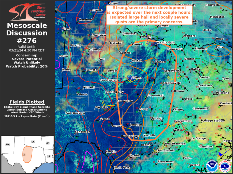
   Mesoscale Discussion 0276
   NWS Storm Prediction Center Norman OK
   0154 PM CDT Thu Mar 21 2024

   Areas affected...Parts of north and central Texas

   Concerning...Severe potential...Watch unlikely

   Valid 211854Z - 212130Z

   Probability of Watch Issuance...20 percent

   SUMMARY...Strong to severe thunderstorm development is expected over
   the next couple hours. Isolated large hail and locally severe gusts
   are the primary concerns. A watch is not currently expected.

   DISCUSSION...Boundary-layer cumulus is gradually deepening in the
   vicinity of a mesoscale low over northwest TX, where steep low-level
   lapse rates are impinging on middle/upper 50s surface dewpoints.
   Isolated convective initiation is underway in this area of focused
   mesoscale ascent. Farther south, cumulus is more shallow along the
   dryline (owing to weak low-level convergence), though deepening
   cumulus is developing west of the dryline in a
   well-mixed/destabilizing boundary layer. Aided by gradually
   strengthening DCVA preceding a midlevel shortwave trough crossing
   west TX, initial thunderstorms will develop/intensify along/south of
   the mesoscale low, where low-level convergence is maximized. Around
   35 kt of effective shear (characterized by a mostly straight
   hodograph) will support initially discrete cells, with an isolated
   hail risk (potentially up to 1.5 inches with the stronger storms)
   and locally strong/severe gusts. Farther south, thunderstorms should
   evolve out of the steep low-level lapse rate plume, with a similar
   risk of isolated hail and slightly greater severe-wind risk, given
   the steeper low-level lapse rates and stronger deep-layer shear.

   With time, these storms should increase in coverage and spread
   eastward, as the large-scale ascent continues to overspread the
   region. This will promote localized upscale growth into several
   loosely organized clusters, though the strongest deep-layer shear
   may be displaced to the south of this activity -- potentially
   limiting convective organization and favoring outflow dominant
   storms. Nevertheless, strong to severe gusts (generally 50-60 mph)
   will become the main concern, though isolated large hail will remain
   possible with the more discrete activity. Current thinking is that
   the severe hail/wind risk may remain too isolated/marginal for a
   watch, though convective trends will be monitored through the
   afternoon.

   ..Weinman/Goss.. 03/21/2024

   ...Please see www.spc.noaa.gov for graphic product...

   ATTN...WFO...FWD...OUN...EWX...SJT...LUB...

   LAT...LON   29909915 29939967 30149991 30600021 31770040 32650038
               33380016 33839983 34029939 34089897 34029836 33799780
               33399747 32239759 30449798 29959857 29909915
|


 @NWSSPC