|
| Mesoscale Discussion 264 |
|
< Previous MD Next MD >
|
|
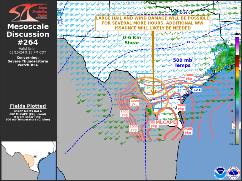
   Mesoscale Discussion 0264
   NWS Storm Prediction Center Norman OK
   0722 PM CDT Fri Mar 15 2024

   Areas affected...Southwest Texas

   Concerning...Severe Thunderstorm Watch 54...

   Valid 160022Z - 160215Z

   The severe weather threat for Severe Thunderstorm Watch 54
   continues.

   SUMMARY...A severe threat is likely to continue for a several more
   hours. Large hail and wind damage will be the primary threats.
   Weather watch issuance will likely be needed to replace WW 54.

   DISCUSSION...The latest radar from Laughlin Air Force Base shows a
   cluster of widely spaced severe storms in the vicinity of the Rio
   Grande River, near and to the south of Eagle Pass and to the
   south-southwest of Laredo. These storms are developing to the east
   of an axis of moderate to strong instability, where the RAP has
   MLCAPE in the 1500 to 3000 J/kg range. Strong surface heating, weak
   large-scale ascent and low-level convergence will likely continue to
   support continued convective development for several more hours this
   evening. The instability along with 700-500 mb lapse rates of 7.5 to
   8 C/km, and 55 knots of 0-6 km shear, evident on the Del Rio WSR-88
   VWP, will be favorable for supercells with large hail. Hailstones
   near 2 inches in diameter will be possible with the strongest of
   cells. Wind damage will also be possible.

   ..Broyles.. 03/16/2024

   ...Please see www.spc.noaa.gov for graphic product...

   ATTN...WFO...CRP...EWX...BRO...

   LAT...LON   27149872 26969915 27059945 27629974 28430049 29110074
               29380002 29069884 28009830 27409849 27149872
|
|
Top/All Mesoscale Discussions/Forecast Products/Home
|
|


 @NWSSPC