|
| Mesoscale Discussion 233 |
|
< Previous MD Next MD >
|
|
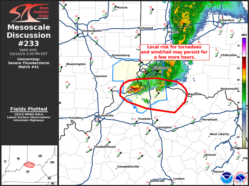
   Mesoscale Discussion 0233
   NWS Storm Prediction Center Norman OK
   0134 PM CDT Thu Mar 14 2024

   Areas affected...parts of far southeastern IN...southwest OH and
   northern KY

   Concerning...Severe Thunderstorm Watch 41...

   Valid 141834Z - 141930Z

   The severe weather threat for Severe Thunderstorm Watch 41
   continues.

   SUMMARY...An ongoing supercell may pose a locally higher risk for
   tornadoes, damaging winds and hail for another few hours before
   weakening.

   DISCUSSION...As of 1825 UTC, regional radar showed downscale growth
   of the previous squall line has resulted in a robust supercell over
   parts of Switzerland County IN and Gallatin county KY. A tornado has
   recently been reported with this storm and radar trends indicate a
   strong mesocyclone with VROTS approaching 50 kt. This supercell may
   persist and present a locally higher risk for tornadoes, damaging
   gusts and hail over the next couple of hours. Low-level shear also
   remains strong along the trialing outflow which will continue to
   favor a supercell mode. At the nose of an instability gradient, the
   storm will eventually outpace the warm sector and should begin to
   slowly weaken. Convective trends will continue to be monitored,
   though a locally higher risk for severe weather is likely over parts
   of southwest OH and northern KY until the storm weakens. A further
   local extension of WW41 may need to be coordinated.

   ..Lyons.. 03/14/2024

   ...Please see www.spc.noaa.gov for graphic product...

   ATTN...WFO...JKL...ILN...LMK...

   LAT...LON   38358403 38408445 38438468 38548511 38608520 38648527
               38798525 38868519 38928508 38958487 38978443 38928412
               38908399 38858387 38768378 38698374 38548380 38428393
               38358403
|
|
Top/All Mesoscale Discussions/Forecast Products/Home
|
|


 @NWSSPC