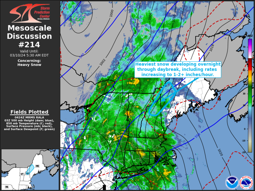
   Mesoscale Discussion 0214
   NWS Storm Prediction Center Norman OK
   1027 PM CST Sat Mar 09 2024

   Areas affected...parts of northern New Hampshire into western Maine

   Concerning...Heavy snow

   Valid 100427Z - 100930Z

   SUMMARY...Sustained heavy snow appears most likely to become focused
   across the mountains of northern New Hampshire into northwestern
   Maine overnight into daybreak Sunday, including hourly rates
   increasing to 1-2+ inches per hour.

   DISCUSSION...A developing surface cyclone appears to be undergoing a
   period of more rapid deepening as it migrates across the northern
   Mid Atlantic region toward southern New England.  Strengthening
   deep-layer ascent to the north-northeast of this feature, supported
   by lower/mid-tropospheric warm advection beneath an increasingly
   difluent and divergent upper flow field, is in the process of
   overspreading much of eastern New York and western New England,
   accompanied by moderate to heavy precipitation.

   Thermodynamic profiles near or below freezing are generally focused
   across the higher terrain, and with further low-level warming, may
   become increasingly confined to the mountains of northern New
   Hampshire into northwestern Maine overnight.  This is where ensemble
   output (including the latest NCEP SREF and HREF) suggest highest
   probabilities for heavy snow rates developing and being maintained,
   perhaps at rates in excess of 2 inches per hour by 09-12Z.

   It appears that precipitable water within the saturating,
   sub-freezing profiles across this region may increase up to around
   .70 inches.  Rapid Refresh forecast soundings indicate that this
   will coincide with a period of intensifying lift within a layer
   between roughly 600-500 mb, where the environment will become most
   conducive to large dendritic ice crystal growth with temperatures
   around -15 C.  It appears that a fairly deep layer layer through the
   lowest few kilometers above ground level may become characterized by
   isothermal profiles near freezing, contributing to potential for
   considerable continuing snow flake growth via aggregation before
   reaching the surface as a "heavy, wet" snow.

   ..Kerr.. 03/10/2024

   ...Please see www.spc.noaa.gov for graphic product...

   ATTN...WFO...GYX...

   LAT...LON   45247007 44937001 44097102 43867142 44037185 44787129
               45567048 45247007
|


 @NWSSPC