|
| Mesoscale Discussion 203 |
|
< Previous MD Next MD >
|
|
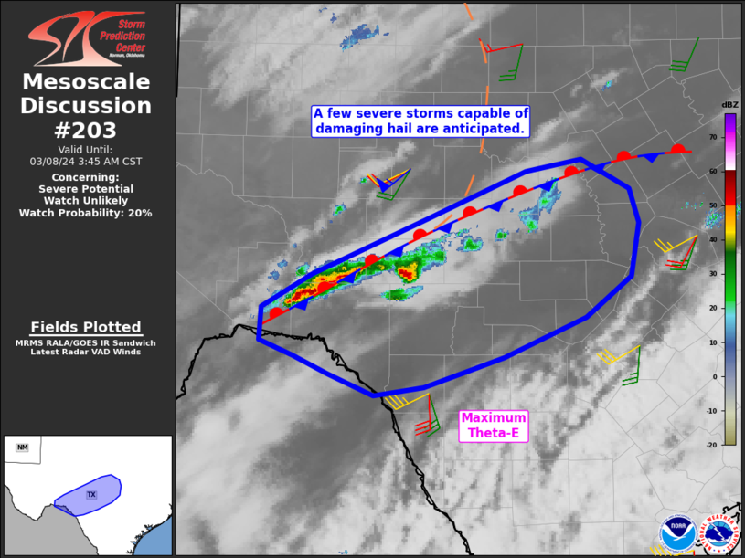
   Mesoscale Discussion 0203
   NWS Storm Prediction Center Norman OK
   0109 AM CST Fri Mar 08 2024

   Areas affected...the middle Rio Grande Valley into parts of central
   Texas

   Concerning...Severe potential...Watch unlikely

   Valid 080709Z - 080945Z

   Probability of Watch Issuance...20 percent

   SUMMARY...A few storms may become severe as they develop
   east/northeastward into central Texas. Large and potentially
   damaging hail will be the primary concern.

   DISCUSSION...Storms are gradually increasing along a stalled
   front/theta-e gradient from Terrell to San Saba Counties where mid
   60s dewpoints are in place. Greater moisture levels exist just
   south, with values to around 70 F. Surface winds remain quite weak
   on both sides of the boundary, resulting in minimal convergence.

   Steep lapse rates exist just above the boundary layer, and it will
   not take much lift to get parcels to the LFC. As such, expect a
   gradual increase in storm coverage along this front, perhaps with a
   supercell or two consolidating out of the elongated area of
   convection. Lengthy hodographs, especially in the mid and upper
   levels, and cold temperatures aloft will likely support hail. Given
   the expected isolated nature of the severe threat, a watch is not
   anticipated at this time.

   ..Jewell/Edwards.. 03/08/2024

   ...Please see www.spc.noaa.gov for graphic product...

   ATTN...WFO...FWD...EWX...SJT...MAF...

   LAT...LON   30050207 30360154 30900029 31349922 31449863 31169811
               30859800 30359809 29979858 29609946 29310032 29240087
               29440135 29610174 29750209 30050207
|
|
Top/All Mesoscale Discussions/Forecast Products/Home
|
|


 @NWSSPC