|
| Mesoscale Discussion 188 |
|
< Previous MD Next MD >
|
|
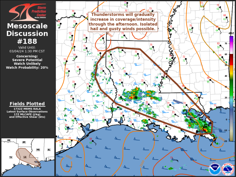
   Mesoscale Discussion 0188
   NWS Storm Prediction Center Norman OK
   1134 AM CST Mon Mar 04 2024

   Areas affected...far east TX into LA and southwest MS

   Concerning...Severe potential...Watch unlikely

   Valid 041734Z - 041930Z

   Probability of Watch Issuance...20 percent

   SUMMARY...Isolated strong to severe thunderstorms are possible
   through the afternoon. Hail (a few instances near 1 inch diameter)
   and gusty winds (to 50 mph) may accompany this activity.

   DISCUSSION...Thunderstorms will continue to increase in
   coverage/intensity over the next few hours from far east TX into
   much of LA. Surface dewpoints in the mid/upper 60s to near 70 F
   beneath steep midlevel lapse rates are fostering MLCAPE generally
   around 1500 J/kg at midday. Meanwhile, 0-6 km effective shear
   magnitudes around 30-35 kt will be marginally favorable for
   supercells. Already a few cells across LA have shown transient, weak
   rotation. This environment will mainly support isolated hail (a few
   instances of near 1 inch diameter) and gusty winds (to 50 mph).

   Vertically veering low-level flow will support some potential for
   low-level rotation, and regional VWP data shows favorably curved
   (albeit small) low-level hodographs. Generally weak low-level winds
   and a lack of well-defined surface boundaries will likely limit
   tornado potential.

   Given the expected transient and isolated nature of any stronger,
   well-organized cells, a watch is not expected at this time.

   ..Leitman/Hart.. 03/04/2024

   ...Please see www.spc.noaa.gov for graphic product...

   ATTN...WFO...JAN...LIX...LCH...SHV...

   LAT...LON   31599450 32109443 32599403 32749353 32689248 31339083
               29828929 29428933 29378996 29899154 30319276 30589356
               31109424 31599450
|
|
Top/All Mesoscale Discussions/Forecast Products/Home
|
|


 @NWSSPC