|
| Mesoscale Discussion 176 |
|
< Previous MD Next MD >
|
|
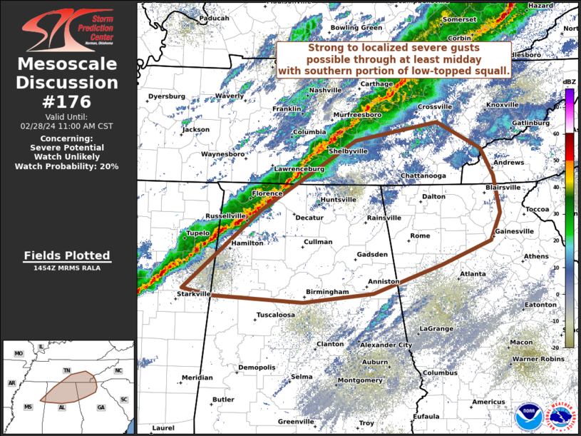
   Mesoscale Discussion 0176
   NWS Storm Prediction Center Norman OK
   0856 AM CST Wed Feb 28 2024

   Areas affected...TN Valley to southern Appalachians

   Concerning...Severe potential...Watch unlikely

   Valid 281456Z - 281700Z

   Probability of Watch Issuance...20 percent

   SUMMARY...Southern portion of a low-topped squall line should
   continue eastward across parts of the Tennessee Valley through at
   least midday. Strong to localized severe wind gusts capable of
   sporadic damage should be the primary threat.

   DISCUSSION...The southern portion of a long, but thin, low-topped
   (echo tops to around 30k ft) squall line extends as far south as
   northeast MS. Large-scale ascent, outside of low-level convergence
   attendant to the southeast-moving cold front, will be gradually
   weakening across the region into the afternoon. However, a few cloud
   breaks noted ahead of the line should yield modest boundary-layer
   destabilization. In conjunction with the northeast extent of low 60s
   surface dew points, the relatively more favorable thermodynamic
   environment should compensate for the diminishing ascent and will
   probably sustain the low-topped convective line eastward through at
   least midday. This scenario is generally supported by 12Z CAM
   guidance. With veered surface and low-level flow, increasing to
   40-45 kts at 1 km AGL, the primary threat should be strong to
   locally severe surface gusts, peaking in the 50-65 mph range. A
   53-kt gust was measured at KMSL at 1437Z.

   ..Grams/Guyer.. 02/28/2024

   ...Please see www.spc.noaa.gov for graphic product...

   ATTN...WFO...GSP...MRX...FFC...OHX...BMX...HUN...MEG...JAN...

   LAT...LON   35578600 35818470 35458401 35098380 34608371 34258386
               33948462 33558572 33448683 33518828 33618872 34638751
               35578600
|
|
Top/All Mesoscale Discussions/Forecast Products/Home
|
|


 @NWSSPC