|
| Mesoscale Discussion 167 |
|
< Previous MD Next MD >
|
|
Mesoscale Discussion 0167
NWS Storm Prediction Center Norman OK
0746 PM CST Tue Feb 27 2024
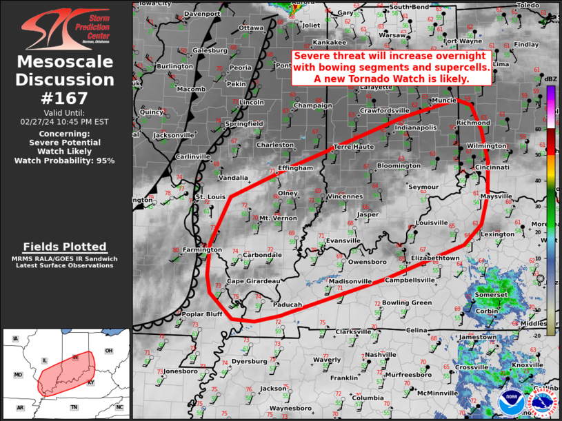
Areas affected...southern Illinois and Indiana into portions of
northern Kentucky and southwest Ohio
Concerning...Severe potential...Watch likely
Valid 280146Z - 280345Z
Probability of Watch Issuance...95 percent
SUMMARY...The severe risk is expected to increase this evening and
overnight upper-level ascent and a fast-moving cold front intersect
with the retreating dryline. Bowing segments and supercells will be
capable of all severe hazards as they spread east along the OH
Valley. A new Tornado Watch will likely be needed in the next 1-2
hours.
DISCUSSION...Over the last hour, surface obs near STL showed the
dryline retreating westward with a surge in dewpoints to the low 60s
F. Evening water-vapor and IR imagery showed large-scale ascent
beginning to impinge on the warm sector across portions of the mid
MS and lower OH Valleys. Weak convection in the well-mixed warm
sector to the west has steadily deepened, and should move into more
robust surface moisture this evening. Additional convection also
appears likely to develop along the cold front surging southeastward
across eastern MO later tonight.
Low 60s F surface dewpoints and ~1000 J/kg of MLCAPE will support
strong updrafts within the warm sector. Very favorable deep-layer
shear (50-60 kt) will support a mix of supercells and short bowing
segments. Damaging gusts and hail appear likely, given the strong
vertical shear and favorable buoyancy. Rapidly increasing low-level
shear (evident on area VADs) may support a risk for tornadoes,
especially with more sustained supercells. A significant tornado
also cannot be ruled out, given very large effective helicity of
400-600 m2/s2 and a 50-60 kt 850 mb jet.
Confidence remains low on the exact timing of convective initiation,
given that some convective inhibition remains. As ascent begins to
deepen, most hi-res guidance, and extrapolation of weaker convection
farther west, suggests new storms should develop in the next 1-2
hours and quickly become severe. With all severe hazards possible, a
new Tornado Watch is likely needed in the next couple of hours for
parts of southern IL/ IN into northern KY and southwestern OH.
..Lyons/Edwards.. 02/28/2024
...Please see www.spc.noaa.gov for graphic product...
ATTN...WFO...ILN...LMK...IND...PAH...ILX...LSX...
LAT...LON 36848841 36748893 36778938 37198983 37468988 37978985
38718946 39188830 40018593 40278485 40188455 39788434
39268422 38748426 38288439 37958475 37428636 36888832
36848841
|
|
Top/All Mesoscale Discussions/Forecast Products/Home
|
|


 @NWSSPC