|
| Mesoscale Discussion 155 |
|
< Previous MD Next MD >
|
|
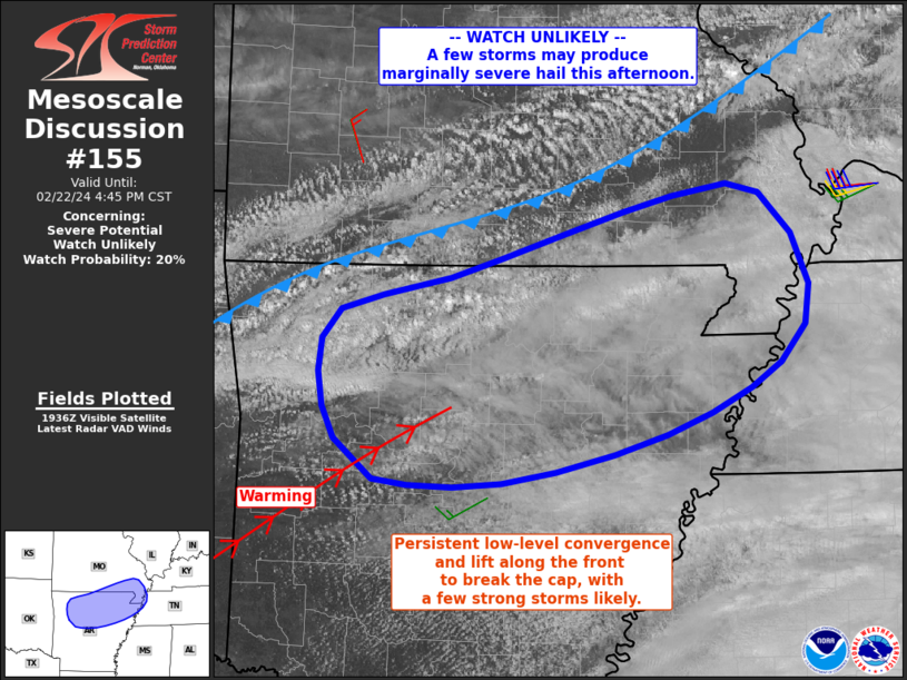
   Mesoscale Discussion 0155
   NWS Storm Prediction Center Norman OK
   0141 PM CST Thu Feb 22 2024

   Areas affected...southern Missouri into northern Arkansas and far
   western Tennessee

   Concerning...Severe potential...Watch unlikely

   Valid 221941Z - 222245Z

   Probability of Watch Issuance...20 percent

   SUMMARY...Scattered storms are forecast to gradually form near a
   cold front as it moves from southern Missouri into northern
   Arkansas. A few storms may produce marginally severe hail.

   DISCUSSION...Visible satellite imagery shows a mixture of cloud
   cover across the area, with distinct areas of heating. Recently,
   low-topped convection has begun to form along western portions of
   the area along the front, within a convergence zone. Area VWPs
   indicate the front is several km deep, which will aid boundary-layer
   lift and eventual cap breakage.

   As gradual low-level warming occurs from the southwest, inhibition
   will eventually be eroded near the front/surface trough. Although
   moisture is limited with less than 1.00" PWAT and dewpoints in the
   50s F, cool temperatures aloft will allow for 500 to perhaps as much
   as 1000 J/kg MLCAPE. Low-level winds are relatively weak, but
   favorable deep-layer shear exists primarily above 500 mb. As such, a
   few storms this afternoon and into the early evening may produce
   marginal severe hail, with strong wind potential most likely late as
   storms produce aggregate outflow and propagate east/southeast toward
   northern MS.

   ..Jewell/Kerr.. 02/22/2024

   ...Please see www.spc.noaa.gov for graphic product...

   ATTN...WFO...PAH...MEG...LZK...SGF...TSA...

   LAT...LON   35739376 36179356 36409259 37009063 37028986 36368942
               35798966 35279068 34939214 34959328 35249362 35739376
|
|
Top/All Mesoscale Discussions/Forecast Products/Home
|
|


 @NWSSPC