|
| Mesoscale Discussion 82 |
|
< Previous MD Next MD >
|
|
Mesoscale Discussion 0082
NWS Storm Prediction Center Norman OK
0327 AM CST Mon Jan 22 2024
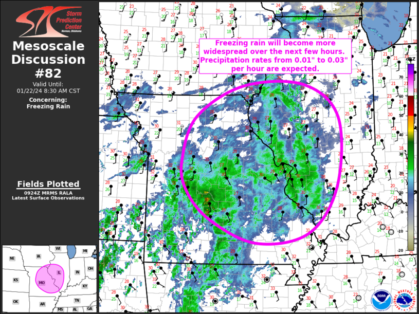
Areas affected...Central/Eastern MO...Western IL
Concerning...Freezing rain
Valid 220927Z - 221430Z
SUMMARY...Freezing rain, with rates generally from 0.01" to 0.03"
per hour, is possible from central/eastern MO into western IL over
the next few hours.
DISCUSSION...Surface observations from central MO through western IL
have increasingly reported freezing rain over the past hour as
persistent light precipitation erodes any dry layers preventing
precipitation from reaching the surface. The heaviest precipitation
is currently moving northeastward through central MO, and the
general expectation is for reports of freezing rain to become more
widespread across eastern MO and western IL over the next hour or
two. Precipitation is generally light, with observations over
central MO near the heaviest precipitation generally reporting 0.01"
to 0.03" an hour. These rates will likely hold as the heaviest
precipitation translates northeastward over the next few hours.
Thereafter, weakening warm-air advection should lead to lighter
precipitation over the Lower OH Valley.
..Mosier.. 01/22/2024
...Please see www.spc.noaa.gov for graphic product...
ATTN...WFO...PAH...ILX...LSX...DVN...SGF...EAX...
LAT...LON 37599269 38319343 39049355 40069311 40829166 40858975
40068867 38368874 37248964 37019124 37599269
|
|
Top/All Mesoscale Discussions/Forecast Products/Home
|
|


 @NWSSPC