|
| Mesoscale Discussion 66 |
|
< Previous MD Next MD >
|
|
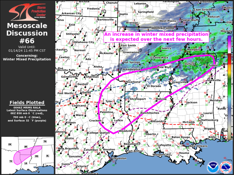
   Mesoscale Discussion 0066
   NWS Storm Prediction Center Norman OK
   0648 PM CST Sun Jan 14 2024

   Areas affected...East TX...northwest LA...southern AR...and northern
   MS

   Concerning...Winter mixed precipitation

   Valid 150048Z - 150545Z

   SUMMARY...An increase in winter mixed precipitation is expected from
   portions of east TX east-northeastward into northern MS over the
   next few hours.

   DISCUSSION...Over the next few hours, a band of low-level
   frontogenesis extending from northeast TX through southern AR into
   northern MS is expected to strengthen in response to increasing
   low-level confluence. Along/south of this feature, the ascending
   branch of the frontogenetic circulation and steady low-level warm
   advection should support an increase in precipitation over the next
   few hours. Radar echoes are gradually increasing across this
   corridor amid cooling cloud tops.

   Forecast soundings generally depict a 2-4 deg C warm nose just below
   850 mb atop a substantial sub-freezing layer (surface temperatures
   in the upper teens to lower/middle 20s). These profiles should
   support a mix of sleet and freezing rain across much of the area,
   with the primary precipitation type expected to transition to sleet
   given an ample low-level sub-freezing layer and nocturnally cooling
   surface temperatures. The one exception may be over the southern
   portions of the discussion area (east-central TX into western LA),
   where a 4-6 deg C warm nose atop a shallower sub-freezing layer may
   favor increasing hydrometeor melting and freezing rain.
   Nevertheless, the potential for impacts from the mixed winter
   precipitation should gradually increase in the 02-06Z time frame.

   ..Weinman.. 01/15/2024

   ...Please see www.spc.noaa.gov for graphic product...

   ATTN...WFO...MEG...JAN...LZK...LCH...SHV...HGX...FWD...

   LAT...LON   30979415 30739472 30989525 31289558 32249571 32979551
               33579493 33939418 34319227 34729040 34898949 34918850
               34768829 34338823 34068862 33528961 32719140 31969268
               30979415
|
|
Top/All Mesoscale Discussions/Forecast Products/Home
|
|


 @NWSSPC