|
| Mesoscale Discussion 55 |
|
< Previous MD Next MD >
|
|
Mesoscale Discussion 0055
NWS Storm Prediction Center Norman OK
1024 AM CST Fri Jan 12 2024
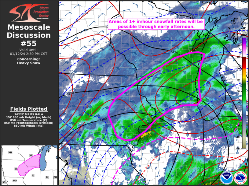
Areas affected...Eastern Iowa into northern Illinois and southern
Wisconsin
Concerning...Heavy snow
Valid 121624Z - 122030Z
SUMMARY...Areas of 1+ in/hour snowfall rates appear probable within
a broader swath of moderate snowfall across eastern Iowa into
southern Wisconsin and northern Illinois through early afternoon.
DISCUSSION...Surface observations over the past couple of hours have
been reporting visibilities between 1/4 to 1/2 mile from eastern IA
into southern WI and far northern IL. Sustained 20-25 knot winds
across eastern IA are supporting areas of blowing snow per blowing
snow model output and web cams, which is contributing to the reduced
visibilities. Further east into WI/IL, weaker winds suggest moderate
to heavy snowfall rates are the primary contributors to the reduced
visibility. Regional radar mosaics support this idea with relatively
short (~1 hour) snow bands noted over the past hour. These bands
appear to be mainly driven by strong warm air advection within the
0-2 km layer based on regional VWP observations. Despite the
magnitude of the warm air advection, 12 UTC and recent RAP forecast
soundings suggest this ascent is displaced from the DGZ within the
3-4 km layer. This will modulate snowfall rates across the broader
region, but heavier snowfall rates at/above 1 in/hour will be
possible within the transient snow bands. This trend should continue
through early/mid afternoon before stronger ascent within the warm
advection regime shifts northeast with the synoptic low.
..Moore.. 01/12/2024
...Please see www.spc.noaa.gov for graphic product...
ATTN...WFO...GRB...LOT...MKX...DVN...ARX...DMX...
LAT...LON 42298784 42288865 42098933 41709012 41229071 40879134
40829179 40969224 41859276 42199268 42539238 43209128
44258906 44358860 44458819 44478769 44388732 43928757
43318770 42818768 42488762 42298784
|
|
Top/All Mesoscale Discussions/Forecast Products/Home
|
|


 @NWSSPC