|
| Mesoscale Discussion 49 |
|
< Previous MD Next MD >
|
|
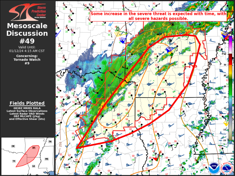
   Mesoscale Discussion 0049
   NWS Storm Prediction Center Norman OK
   0241 AM CST Fri Jan 12 2024

   Areas affected...Northeast TX...Northwest LA...central/southern AR

   Concerning...Tornado Watch 9...

   Valid 120841Z - 121015Z

   The severe weather threat for Tornado Watch 9 continues.

   SUMMARY...Some increase in the severe threat is expected with time.
   All severe hazards are possible. New watch issuance is likely before
   the expiration of Tornado Watch 9.

   DISCUSSION...Extensive convection is ongoing at 0830 UTC from
   northeast TX into AR, in advance of a strong mid/upper-level
   shortwave trough moving across north TX. Low-level moisture
   continues to gradually increase across the effective warm sector,
   with MLCAPE currently in the 1000-1500 J/kg range. As a 100+ kt
   midlevel jet associated with the approaching shortwave impinges upon
   the ArkLaTex region, already-favorable deep-layer flow/shear will
   continue to increase, and increasingly organized/sustained storm
   structures are expected to evolve through the morning.

   Discrete cells have struggled to mature in advance of the main
   convective line thus far, though a couple prefrontal supercells may
   evolve with time, with an attendant threat of all severe hazards.
   Otherwise, the severe-wind threat is expected to increase as the
   primary convective line accelerates eastward through the morning.
   Strong low-level flow/shear will support some threat for significant
   (65+ kt) gusts, as well as some potential for line-embedded
   tornadoes.

   With WW 9 scheduled to expire at 4 AM CST and some severe threat
   likely to spread well downstream, new watch issuance is likely for
   parts of the MCD area a little later this morning.

   ..Dean/Edwards.. 01/12/2024

   ...Please see www.spc.noaa.gov for graphic product...

   ATTN...WFO...JAN...LZK...SHV...HGX...FWD...

   LAT...LON   31199642 32749531 33599457 34789348 35169278 35229186
               35189145 34879127 34289147 33499182 32579262 32109340
               31749423 31469502 31199642
|
|
Top/All Mesoscale Discussions/Forecast Products/Home
|
|


 @NWSSPC