|
| Mesoscale Discussion 29 |
|
< Previous MD Next MD >
|
|
Mesoscale Discussion 0029
NWS Storm Prediction Center Norman OK
0915 AM CST Tue Jan 09 2024
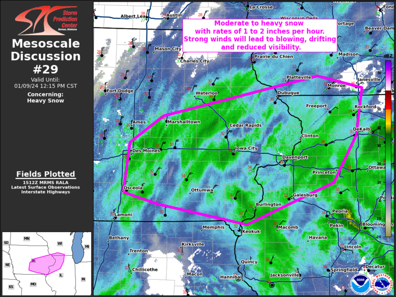
Areas affected...Eastern Iowa...northwest Illinois...and far
southwest Wisconsin.
Concerning...Heavy snow
Valid 091515Z - 091815Z
CORRECTED FOR INCORRECT SURFACE LOW LOCATION
SUMMARY...Moderate to heavy snow with rates of 1 to 2 inches per
hour are expected into the early afternoon. Strong winds will lead
to blowing, drifting, and reduced visibility.
DISCUSSION...A 987mb surface low currently northeast of St. Louis
this morning will continue to deepen through the day as it moves
north into Michigan and deepens below 980mb. Within the last hour,
snowfall rates have started to increase across eastern Iowa within
the deformation region of the cyclone. Expect this moderate to heavy
snow to shift eastward into northern Illinois and Wisconsin during
the day in response to the deepening/moving cyclone. Winds are
already around 20 mph with gusts to 30 mph but are expected to
strengthen further to around 25 mph with gusts to 40 mph this
afternoon as the pressure gradient tightens. Widespread blowing and
drifting snow is expected with localized blizzard conditions
possible.
..Bentley.. 01/09/2024
...Please see www.spc.noaa.gov for graphic product...
ATTN...WFO...LOT...ILX...MKX...DVN...ARX...DMX...
LAT...LON 40859304 41019375 41789363 42189297 42798981 42608890
41898904 41178951 40559126 40859304
|
|
Top/All Mesoscale Discussions/Forecast Products/Home
|
|


 @NWSSPC