|
| Mesoscale Discussion 13 |
|
< Previous MD Next MD >
|
|
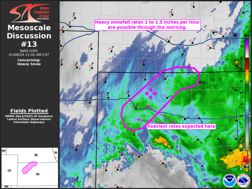
   Mesoscale Discussion 0013
   NWS Storm Prediction Center Norman OK
   0739 AM CST Mon Jan 08 2024

   Areas affected...northwest KS...south-central NE

   Concerning...Heavy snow

   Valid 081339Z - 081745Z

   SUMMARY...Heavy snowfall rates around 1 to 1.5 inches per hour are
   possible through the morning.

   DISCUSSION...A mesoscale band of heavier snowfall rates appears to
   be developing across northwest KS on the northern periphery of a
   warm conveyor belt located over the southern-central Great Plains.
   Frontogenetic forcing for ascent is forecast to continue to
   strengthen during the morning across western KS and eventually into
   southern NE by late morning.  The 12 UTC Dodge City raob showed a
   moist profile and an above-freezing layer from the surface through
   800 mb.  A surface front is draped southwest to northeast from far
   southwestern KS north-northeast into northwest KS (i.e., located to
   the northwest of Dodge City).  The colder airmass north of the front
   will support snow as the precipitation type.  Model guidance
   indicates upwards of 0.10 to 0.15 inches per hour liquid-equivalent
   precipitation across northwest KS this morning.  As a result of
   nearly 10:1 snow ratios, expecting 1 to 1.5 inches per hour (locally
   heavier bursts are possible) as lift continues to strengthen during
   the morning.

   ..Smith.. 01/08/2024

   ...Please see www.spc.noaa.gov for graphic product...

   ATTN...WFO...GID...DDC...GLD...

   LAT...LON   40030000 40149952 40109896 39989880 39709884 39569942
               38630058 38560091 38670115 38950127 39170123 40030000
|
|
Top/All Mesoscale Discussions/Forecast Products/Home
|
|


 @NWSSPC