Mesoscale Discussion 2077
NWS Storm Prediction Center Norman OK
0341 PM CST Wed Dec 29 2021
Areas affected...Parts of southeastern AR...northeastern
LA...northern MS...and southwestern TN
Concerning...Tornado Watch 569...
Valid 292141Z - 292245Z
The severe weather threat for Tornado Watch 569 continues.
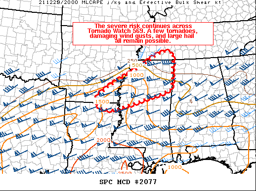
SUMMARY...The severe risk continues across Tornado Watch 569. A few
tornadoes, damaging wind gusts, and large hail all remain possible
this afternoon and evening.
DISCUSSION...A southwest-northeast oriented line of broken
convection with embedded supercell structures will continue
advancing east-northeastward ahead of a frontal wave draped across
parts of the Mid-South. Ahead of the frontal wave across the open
warm sector, rich boundary-layer moisture (middle/upper 60s
dewpoints) combined with pockets of diurnal heating are supporting
500-1500 J/kg MLCAPE, where the latest mesoanalysis depicts 55-65
knots effective bulk shear. Additionally, the latest VWP data from
GWX shows 55 knot winds at 2.5 to 3 km, indicative of the
strengthening low-level jet overspreading the warm sector.
Relatively backed surface winds beneath the strengthening low-level
flow are evident across northern MS, which are contributing to
150-250 m2/s2 effective SRH ahead of the ongoing convection. While
deep-layer shear vectors and storm motion vectors are oriented
largely parallel to the frontal wave (yielding modest upscale
growth), shear vectors become oriented off the boundary with
northward extent into parts of MS. This could support more discrete
convective modes, which combined with the favorable and increasing
low-level SRH should favor an increasing risk of a few tornadoes,
damaging wind gusts, and large hail.
..Weinman/Hart.. 12/29/2021
...Please see www.spc.noaa.gov for graphic product...
ATTN...WFO...HUN...MEG...JAN...LZK...SHV...
LAT...LON 33399220 33819165 34389052 34858972 35388872 35338814
35068819 34038824 33628834 33059024 32739139 32759201
32969237 33229234 33399220
|


 @NWSSPC