|
| Mesoscale Discussion 2069 |
|
< Previous MD Next MD >
|
|
Mesoscale Discussion 2069
NWS Storm Prediction Center Norman OK
0540 PM CST Tue Dec 28 2021
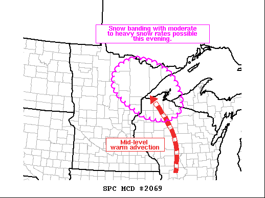
Areas affected...Northern Wisconsin into northeast Minnesota
Concerning...Heavy snow
Valid 282340Z - 290345Z
SUMMARY...Snow banding is probable over the next few hours across
northern Wisconsin into northeast Minnesota. Moderate to heavy
snowfall rates up to 1 inch/hour are possible. Lake-enhanced
snowfall is also likely along the North Shore of MN.
DISCUSSION...Regional radar mosaics over the past hour have shown a
gradual weakening of the stratiform precipitation over
central/southern WI with a corresponding increase across northern
portions of the state into northeast MN. Surface observations under
this precipitation show occasional visibility reductions to 1/2 to
1/4 mile. This uptick in snowfall is likely the result of increasing
ascent ahead of an approaching vorticity maxima (noted in
water-vapor and radar imagery over south-central MN), as well as
more focused ascent within a swath of warm air advection between
850-700 mb. Forecast soundings from northeast MN show a gradual
deepening of the dentritic growth zone in the coming hours with much
of this layer residing within a favorable zone of lift.
Additionally, transient frontogenesis may further augment and
organize mesoscale ascent. The combined result will be the potential
for at least a loosely organized snow band that will support
moderate to heavy snowfall rates up to 1 inch/hour. With Lake
Superior surface temperatures in the upper 30s/low 40s and
east/southeast winds, lake-effect enhancement is likely along the
North Shore where heavier snowfall rates are probable.
..Moore.. 12/28/2021
...Please see www.spc.noaa.gov for graphic product...
ATTN...WFO...MQT...GRB...DLH...
LAT...LON 45929216 46569336 47059405 47729413 48159370 48449288
48339173 47969071 47439018 46668977 46298982 46019005
45789052 45749124 45929216
|
|
Top/All Mesoscale Discussions/Forecast Products/Home
|
|


 @NWSSPC