|
| Mesoscale Discussion 1972 |
|
< Previous MD Next MD >
|
|
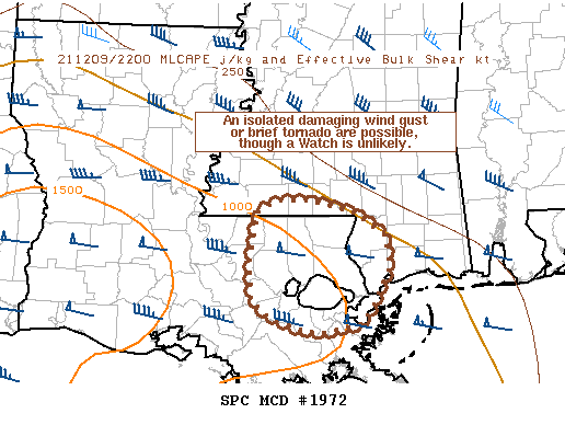
   Mesoscale Discussion 1972
   NWS Storm Prediction Center Norman OK
   0503 PM CST Thu Dec 09 2021

   Areas affected...Parts of southeastern Louisiana and southern
   Mississippi

   Concerning...Severe potential...Watch unlikely

   Valid 092303Z - 100030Z

   Probability of Watch Issuance...5 percent

   SUMMARY...Loosely organized convective clusters will continue
   tracking northeastward, capable of producing a localized damaging
   wind gust or a brief tornado.

   DISCUSSION...Recent radar trends depict some modest convective
   organization over portions of southeastern LA, where a moist
   boundary-layer (dewpoints in the upper 60s/lower 70s) is supporting
   low-topped surface-based showers. The VWP from LIX shows veering
   winds in the lowest 2 km, resulting in 0-1 km SRH of 150-200 m2/s2
   north of a diffuse warm front and deep-layer shear near 50 knots.
   These factors will support some potential for a strong to locally
   damaging wind gust, and a brief tornado cannot be entirely ruled
   out. The localized nature of the threat and low probability of
   occurrence limits the need for a Watch.

   ..Weinman/Grams.. 12/09/2021

   ...Please see www.spc.noaa.gov for graphic product...

   ATTN...WFO...JAN...LIX...

   LAT...LON   29969081 30119099 30569102 31039093 31179067 31179028
               31038973 30808938 30458931 30068953 29878965 29779017
               29839048 29969081
|
|
Top/All Mesoscale Discussions/Forecast Products/Home
|
|


 @NWSSPC