|
| Mesoscale Discussion 1927 |
|
< Previous MD Next MD >
|
|
Mesoscale Discussion 1927
NWS Storm Prediction Center Norman OK
1044 AM CDT Fri Oct 29 2021
Areas affected...extreme northeast North Carolina into southeast
Virginia
Concerning...Severe potential...Watch unlikely
Valid 291544Z - 291645Z
Probability of Watch Issuance...20 percent
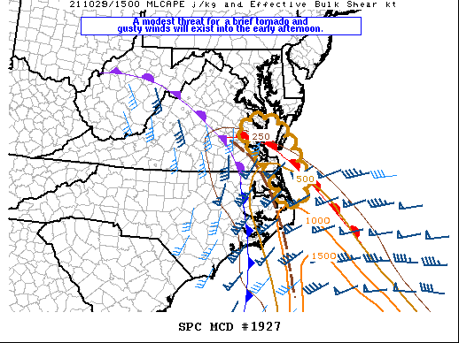
SUMMARY...Low-topped convection will pose a modest threat for a
couple of locally strong wind gusts and a brief tornado. At this
time the overall magnitude and spacial extent of any severe threat
does not appear to warrant a WW.
DISCUSSION...An arcing band of low-topped convection extends from
southeast VA into far northeast NC. Activity is developing along a
pre-frontal convergence band extending inland from the Gulf Stream.
A narrow corridor of weak instability is indicated with 500-1000
J/kg MLCAPE along and south of a warm front that extends across
southeast VA. A relatively small window will exist for this
convection to become better organized and capable of producing a
couple of locally strong wind gusts and perhaps a brief tornado
where sizeable low-level hodographs exists across coastal NC and
southeast VA. The inland advance of the warm sector will remain
limited, keeping the spatial extent of the threat relatively small.
..Dial/Hart.. 10/29/2021
...Please see www.spc.noaa.gov for graphic product...
ATTN...WFO...AKQ...MHX...
LAT...LON 37777595 36187514 35757570 36687623 37727711 37777595
|
|
Top/All Mesoscale Discussions/Forecast Products/Home
|
|


 @NWSSPC