|
| Mesoscale Discussion 1901 |
|
< Previous MD Next MD >
|
|
Mesoscale Discussion 1901
NWS Storm Prediction Center Norman OK
0541 PM CDT Mon Oct 25 2021
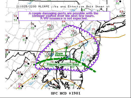
Areas affected...portions of northern Maryland and northern Delaware
into southeast Pennsylvania and southern into central New Jersey
Concerning...Severe potential...Watch unlikely
Valid 252241Z - 260045Z
Probability of Watch Issuance...20 percent
SUMMARY...A couple damaging gusts remain possible with some of the
stronger storms over the next couple of hours. The severe threat
should gradually diminish later this evening with boundary-layer
stabilization. A WW issuance is not expected given the short-lived
nature of the severe threat.
DISCUSSION...A west-east oriented band of convection has become
established along a confluence zone across central MD/DE over the
past couple of hours. While mainly pulse cellular and brief
multicellular storms comprise the convective band, a couple of the
stronger storm cores have produced damaging gusts within the past
hour, particularly across Fairfax County, VA. This convective band
is progressing northward across a reservoir of 500+ J/kg MLCAPE and
35-45 kts of effective bulk shear (driven primarily by sfc-500 mb
speed shear within a unidirectional southerly vertical wind
profile). As such, a couple damaging gusts remain possible with the
longer lasting cells/clusters given the available buoyancy. However,
RAP forecast soundings suggest that the aforementioned buoyancy is
driven primarily by a heated/mixed boundary layer. Given nocturnal
cooling already underway, the boundary layer is expected to
stabilize. As such, the ongoing damaging gust threat is expected to
be relatively brief (i.e. continuing for only a few more hours
before diminishing), and a WW issuance is not anticipated.
..Squitieri/Hart.. 10/25/2021
...Please see www.spc.noaa.gov for graphic product...
ATTN...WFO...PHI...CTP...LWX...
LAT...LON 38907522 38987631 38977694 38987731 38987769 39157771
39597747 40357648 40827598 40867569 40737524 40557475
40337443 39877411 39447421 39097460 38887491 38907522
|
|
Top/All Mesoscale Discussions/Forecast Products/Home
|
|


 @NWSSPC