|
| Mesoscale Discussion 1893 |
|
< Previous MD Next MD >
|
|
Mesoscale Discussion 1893
NWS Storm Prediction Center Norman OK
0525 PM CDT Sun Oct 24 2021
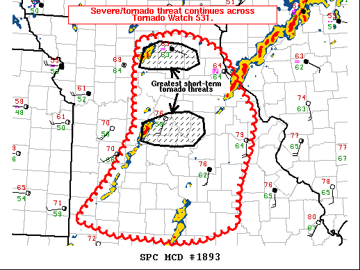
Areas affected...portions of western into central Missouri
Concerning...Tornado Watch 531...
Valid 242225Z - 250030Z
The severe weather threat for Tornado Watch 531 continues.
SUMMARY...The threat for severe storms, including tornadoes,
continues across Tornado Watch 0531 in central MO, and is expected
to persist through the remainder of the evening. The greatest short
term threat is associated with storms immediately ahead of the cold
front and in proximity to the warm front, though the severe threat
may increase further south with time.
DISCUSSION...Multiple sustained semi-discrete supercell structures
are in progress across portions of north-central into central MO
immediately ahead of a cold front and within proximity to a diffuse
warm front. In addition, storms are also attempting to mature
further south along the cold front into southwest MO, as well as
with a second confluence zone east of SGF. Tornadoes have been
reported over the past few hours across northern/central MO with
storms closer to the warm front, where latest METAR observations
depict more backed surface flow. These storms have the greatest
threat of continued tornado potential in the short term.
The low-level jet is expected to intensify going into the evening
hours across portions of central into eastern MO. 2154Z SGF VWP
showed over 200 m2/s2 SRH, and these values are expected to
gradually increase this evening. As such, a tornado threat may
develop with any sustained supercell structures that manage to
develop in southern MO. In addition, severe hail and damaging
rear-flank downdraft winds may also accompany any mature supercells
as well.
..Squitieri/Hart.. 10/24/2021
...Please see www.spc.noaa.gov for graphic product...
ATTN...WFO...LSX...DVN...SGF...EAX...
LAT...LON 37229123 37009191 36959239 37079369 37299445 37989380
38819329 39769332 40229324 40349240 40219189 40039150
39729130 39009083 38469093 37809119 37229123
|
|
Top/All Mesoscale Discussions/Forecast Products/Home
|
|


 @NWSSPC