|
| Mesoscale Discussion 1842 |
|
< Previous MD Next MD >
|
|
Mesoscale Discussion 1842
NWS Storm Prediction Center Norman OK
0730 PM CDT Tue Oct 12 2021
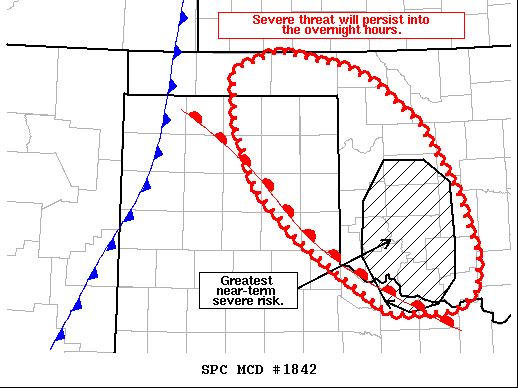
Areas affected...Eastern Texas Panhandle and Western Oklahoma
Concerning...Tornado Watch 523...
Valid 130030Z - 130230Z
The severe weather threat for Tornado Watch 523 continues.
SUMMARY...The severe weather threat continues across WW 523. The
greatest near-term threat will remain across western OK associated
with isolated supercells, but a second round of storms remains
likely later this evening.
DISCUSSION...Latest regional radar imagery shows a few supercells
moving north/northeastward across far north Texas and western
Oklahoma. The west-central OK supercell has exhibited strong
low-level rotation, indicating that the ample low-level shear over
the region (200-300 m2/s2 0-1 km SRH sampled by the KFDR VWP and
analyzed in recent RAP mesoanalysis) is compensating for lingering
mixed-layer inhibition. The tornado threat associated with this
storm will continue for the near term, and may persist into the late
evening hours as low-level wind fields strengthen in response to the
deepening surface low to the north.
Additional discrete cells are possible across southwest OK and/or
the eastern TX Panhandle along the warm front within the next 1-2
hours, but weak forcing for ascent, substantial mid-level dry air
entrainment, and the onset of diurnal cooling make confidence in
discrete storm coverage uncertain. Latest hi-res guidance has
depicted this potential, but run-to-run consistency has been
somewhat poor, further reducing confidence.
Additional storms are likely later this evening/overnight as
stronger lift associated with the approach of the main upper-level
wave (manifesting as increasing showers and weak convection over the
southern High Plains) overspreads the region. Increasingly
meridional flow along the initiating cold front will support mostly
linear storm modes, but increasing low-level shear within the warm
sector should maintain a QLCS tornado threat over the watch area.
..Moore.. 10/13/2021
...Please see www.spc.noaa.gov for graphic product...
ATTN...WFO...OUN...DDC...LUB...AMA...
LAT...LON 34500004 34920063 35460117 36180145 36790146 37010086
36829988 36679951 36149884 35329834 34639813 34259816
34069842 34029859 34039936 34500004
|
|
Top/All Mesoscale Discussions/Forecast Products/Home
|
|


 @NWSSPC