|
| Mesoscale Discussion 1809 |
|
< Previous MD Next MD >
|
|
Mesoscale Discussion 1809
NWS Storm Prediction Center Norman OK
0507 PM CDT Thu Oct 07 2021
Areas affected...Portions of the Great Basin
Concerning...Severe potential...Watch unlikely
Valid 072207Z - 080000Z
Probability of Watch Issuance...5 percent
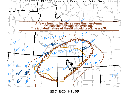
SUMMARY...A few strong to locally severe thunderstorms are possible
through this evening across portions of the Great Basin. Isolated
instances of gusty winds and near-severe hail are the primary severe
threats. The spotty nature of any severe threat will likely preclude
a severe weather watch.
DISCUSSION...Radar imagery over the past hour or so shows widely
scattered and mostly poorly disorganized multicell thunderstorms
across portions of the Great Basin as a mid-level shortwave trough
approaches the area. The strongest storm during this time has been
located over Cassia County in southern Idaho, where periodic updraft
organization has allowed this thunderstorm to remain near severe
limits (MRMS MESH near 1 inch). Occasional
strengthening/organization of nearby/new thunderstorm updrafts are
possible over the next several hours due to effective bulk shear
near 40 knots and modest instability (e.g., MLCAPE near 500 J/kg) --
best overlap over southern/southeastern Idaho. Isolated instances of
marginally severe hail and gusty winds will be possible with the
strongest storms through mid/late evening before instability weakens
further.
Overall, the spotty nature of any severe threat should preclude a
severe weather watch.
..Elliott/Thompson.. 10/07/2021
...Please see www.spc.noaa.gov for graphic product...
ATTN...WFO...RIW...SLC...PIH...BOI...LKN...
LAT...LON 41121610 41781565 42601456 43491205 43371062 43111016
42440985 41741063 40911180 39841367 39931482 40261590
40611638 41121610
|
|
Top/All Mesoscale Discussions/Forecast Products/Home
|
|


 @NWSSPC