|
| Mesoscale Discussion 1789 |
|
< Previous MD Next MD >
|
|
Mesoscale Discussion 1789
NWS Storm Prediction Center Norman OK
0701 PM CDT Tue Sep 28 2021
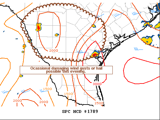
Areas affected...Portions of south Texas
Concerning...Severe potential...Watch unlikely
Valid 290001Z - 290130Z
Probability of Watch Issuance...5 percent
SUMMARY...Isolated strong/severe storms ongoing near the Mexican
border and far south Texas may produce a few severe wind or hail
reports over the next several hours. Storm coverage is expected to
gradually decrease with the loss of diurnal heating suggesting a
watch is not needed.
DISCUSSION...On the southern fringes of a weak upper low observed
from regional WV imagery across the southern Rockies, isolated to
widely scattered thunderstorms are ongoing across portions of
northern Mexico and southern Texas. Surface obs and SPC mesoanalysis
show these storms are ongoing in a warm, moist and unstable
environment with 2000-2500 J/kg of MLCAPE and 2-6km lapse rates of
7-8 C/km. Vertical shear remains weak with only 25-30 kts of
deep-layer shear in place owing to relatively weak mid-level flow.
The favorable buoyancy/shear profiles should be sufficient for a few
organized multicells and perhaps a weak supercell.
As ongoing storms move to the east northeast with time, occasional
strengthening is possible, with a risk for damaging downburst winds
or hail. Recent radar trends have shown this with two lead storms
over Zavala and Frio counties over the last half hour. The
downstream environment should remain favorable for a lower-end
severe risk for at least a couple more hours. After sunset,
increasing nocturnal inhibition and the movement of the main
synoptic ascent from the upper low away from convection should
result in a gradual downtrend in coverage/intensity. Storms may
linger for a few hours after dark across the southern parts of the
discussion area, closer to the coast, where a greater reservoir of
warm/unstable air exists. However, weak vertical shear suggests
little organization potential and overall confidence in convective
evolution is low. Given the limited spatial/temporal threat window
for wind and hail, a weather watch is unlikely.
..Lyons/Grams.. 09/29/2021
...Please see www.spc.noaa.gov for graphic product...
ATTN...WFO...CRP...EWX...
LAT...LON 29080079 29460052 29710014 29899944 29899854 29269720
29039714 28729709 28359717 27989743 27769818 27769828
27829910 27879942 27889997 29080079
|
|
Top/All Mesoscale Discussions/Forecast Products/Home
|
|


 @NWSSPC