|
| Mesoscale Discussion 1772 |
|
< Previous MD Next MD >
|
|
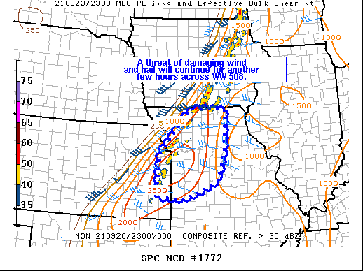
   Mesoscale Discussion 1772
   NWS Storm Prediction Center Norman OK
   0625 PM CDT Mon Sep 20 2021

   Areas affected...far eastern KS into western and north-central MO

   Concerning...Severe Thunderstorm Watch 508...

   Valid 202325Z - 210100Z

   The severe weather threat for Severe Thunderstorm Watch 508
   continues.

   SUMMARY...Damaging gusts and hail will continue to pose a threat
   across WW 508 the next few hours.

   DISCUSSION...A couple of bands of strong to severe thunderstorms
   have developed near the eastward-advancing cold front this evening
   from far eastern KS into western and north-central MO. Convective
   mode has tended to be clusters and line segments, though a couple of
   more discrete supercells also are persisting. One such cell produced
   several severe hail reports in Johnson County KS the past hour or so
   and any more discrete convection will continue to pose a threat for
   severe hail for another couple of hours.

   Large-scale ascent is more modest across the region compared to
   further north across IA/MN/WI, but MLCAPE around 1500-2500 J/kg and
   effective shear magnitudes of 30-40 kt will continue to support
   organized structures developing along the cold front through the
   evening. In addition to the hail threat with more discrete cells,
   bowing segments also may produce damaging gusts. The overall severe
   threat should wane by around 03z as boundary-layer inhibition
   increases and a lack of a stronger low level jet precludes more
   intense/well-organized linear convection from materializing.

   ..Leitman.. 09/20/2021

   ...Please see www.spc.noaa.gov for graphic product...

   ATTN...WFO...LSX...SGF...EAX...TOP...ICT...

   LAT...LON   39119507 40549381 40539241 39259244 38909253 38269269
               37829355 37649415 37709517 39119507
|
|
Top/All Mesoscale Discussions/Forecast Products/Home
|
|


 @NWSSPC